IMAGES TAKEN NEAR TO
Edward VII Avenue, NEWPORT, NP20 4NH
Introduction
This page details the photographs taken nearby to Edward VII Avenue, NP20 4NH by members of the Geograph project.
The Geograph project started in 2005 with the aim of publishing, organising and preserving representative images for every square kilometre of Great Britain, Ireland and the Isle of Man.

There are currently over 7.5m images from over14,400 individuals and you can help contribute to the project by visiting https://www.geograph.org.uk
Image Map
Images are licensed for reuse under creativecommons.org/licenses/by-sa/2.0
Notes
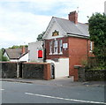
- Clicking on the map will re-center to the selected point.
- The higher the marker number, the further away the image location is from the centre of the postcode.
Image Listing (177 Images Found)
Images are licensed for reuse under creativecommons.org/licenses/by-sa/2.0
Image
Details
Distance
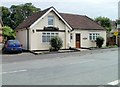
1
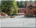
Kings Acre, Newport
Kings Acre is a development of houses and flats, built c1999, on the south side of Fields Park Road.
Image: © Jaggery
Taken: 25 Jul 2010
0.00 miles
2
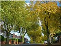
Edward VII Avenue, Newport
Autumn colour from plane trees.
Image: © Robin Drayton
Taken: 23 Oct 2013
0.02 miles
3
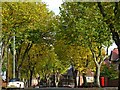
Edward VII Avenue, Newport
Autumn colour from plane trees.
Image: © Robin Drayton
Taken: 23 Oct 2013
0.05 miles
4
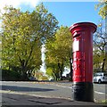
Two kings, Newport
A newly painted George V postbox at the junction of Preston Avenue and Edward VII Avenue.
Another view of this postbox http://www.geograph.org.uk/photo/3716086 .
Image: © Robin Drayton
Taken: 23 Oct 2013
0.05 miles
5
The Coach House, Fields Park Road, Newport
House located opposite the turning for Fields Park Avenue.
Image: © Jaggery
Taken: 25 Jul 2010
0.06 miles
6
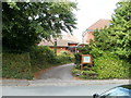
Entrance to Nant Coch church, Newport
The church http://www.geograph.org.uk/photo/1987139 is set back from the road and partly hidden by trees, so despite the name board outside, it's easy to miss the turning if you're not sure exactly where it is - which is on Fields Park Road, just a few metres west of the turning for Kings Acre and a few metres east of the turning for the western part of Fields Park Avenue.
Image: © Jaggery
Taken: 25 Jul 2010
0.06 miles
7
Nant Coch church, Newport
Located at 68 Fields Park Road. Nant Coch is an Evangelical Christian Fellowship which was formed in 1942. It met originally at Nant Coch House on Risca Road, now Rougemont School.
Image: © Jaggery
Taken: 25 Jul 2010
0.06 miles
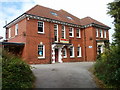
8
1-5 Kings Acre, Newport
Kings Acre is a development of houses and flats built c1999 on the south side of Fields Park Road.
Seen here are 1-5 Kings Acre.
Image: © Jaggery
Taken: 25 Jul 2010
0.06 miles
9
St Catherine's Nursing Home, Newport
Located at 59 Fields Park Road. Privately owned care home with nursing, accommodating 30 residents.
Image: © Jaggery
Taken: 25 Jul 2010
0.06 miles
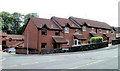
10
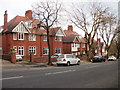
Edward VII Avenue, Newport
Houses on the north side of Edward VII Avenue, between the Woodville Road and Preston Avenue junctions.
Image: © Jaggery
Taken: 12 Dec 2009
0.06 miles