IMAGES TAKEN NEAR TO
Oakfield Road, NEWPORT, NP20 4LZ
Introduction
This page details the photographs taken nearby to Oakfield Road, NP20 4LZ by members of the Geograph project.
The Geograph project started in 2005 with the aim of publishing, organising and preserving representative images for every square kilometre of Great Britain, Ireland and the Isle of Man.

There are currently over 7.5m images from over14,400 individuals and you can help contribute to the project by visiting https://www.geograph.org.uk
Image Map
Images are licensed for reuse under creativecommons.org/licenses/by-sa/2.0
Notes
- Clicking on the map will re-center to the selected point.
- The higher the marker number, the further away the image location is from the centre of the postcode.
Image Listing (399 Images Found)
Images are licensed for reuse under creativecommons.org/licenses/by-sa/2.0
Image
Details
Distance
1
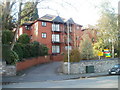
Aragon House, Oakfield Road, Newport
Three-storey building, near the eastern end of Oakfield Road, containing 14 flats.
Image: © Jaggery
Taken: 2 Mar 2011
0.03 miles
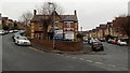
2
Up Bryngwyn Road, Newport
Bryngwyn Road ascends from Llanthewy Road towards Risca Road.
Image: © Jaggery
Taken: 14 Oct 2018
0.04 miles
3
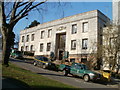
Newport Civic Centre entrance number 4
Viewed across Clytha Park Road. The date on the building is in Roman numerals, MCMXXXIX (1939).
The Grade II* list Civic Centre was commissioned by Newport Corporation in 1936. The first sod was cut by King George VI and Queen Elizabeth on July 4th 1937. The shell of the building was largely complete and partly in use by 1939, though it was another 25 years before the work was finished, with the completion of the central entrance hall, stair and tower in 1964. During the Second World War, uncompleted parts had been roofed over and used by the Admiralty.
Image: © Jaggery
Taken: 2 Mar 2011
0.05 miles
4
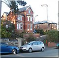
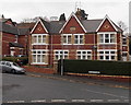
Houses at the eastern end of Oakfield Road, Newport
The houses are near the corner of Clytha Park Road. The ghostly white structure in the background is the Civic Centre clock tower http://www.geograph.org.uk/photo/2198118 bathed in early spring sunshine.
Image: © Jaggery
Taken: 2 Mar 2011
0.05 miles
5
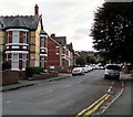
Late Victorian houses, Bryngwyn Road, Newport
The year 1896 is inscribed on the central gable of the semi-detached
houses at the NE end of Bryngwyn Road, viewed from Llanthewy Road.
Image: © Jaggery
Taken: 2 Dec 2013
0.06 miles
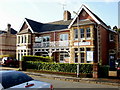
6
Office suites to let in Llanthewy Road, Newport
The suites to let are in number 10 Llanthewy Road, on the left. The right side is Heron House, number 1 Bryngwyn Road. The nameboard shows hhfm, a trading name of Heron House Financial Management Limited.
Image: © Jaggery
Taken: 2 Dec 2013
0.06 miles
7
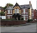
Heron House, 1 Bryngwyn Road, Newport
Heron House on the right is the office of Heron House Financial Management Limited.
Image: © Jaggery
Taken: 14 Oct 2018
0.06 miles
8
2 and 4 Llanthewy Road, Newport
Located at the lower end of Llanthewy Road, adjacent to roundabout to the south of the Civic Centre.
At 2 Llanthewy Road is Cox & Hitchcock's Dental Group surgery.
At 4 Llanthewy Road is The Newport Clinic of Holistic Health.
Image: © Jaggery
Taken: 10 Dec 2009
0.06 miles
9
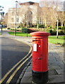
George VI postbox in front of Magistrates' Court, Newport
A George VI postbox stands on the Faulkner Road side of the roundabout near the southern edge of the Civic Centre. About 50 metres away, partly obscured by trees, is the Magistrates Court building, a part of the Civic Centre.
Image: © Jaggery
Taken: 10 Dec 2009
0.06 miles
10
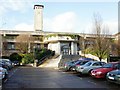
Newport Crown Court
Adjacent to the Magistrates Court http://www.geograph.org.uk/photo/1613997 is Newport Crown Court, on the southeastern side of the Civic Centre. The entrance to the court shown here is up a flight of about two dozen steps.
Reassuringly, the time shown on the Civic Centre clock tower was accurate.
Image: © Jaggery
Taken: 10 Dec 2009
0.06 miles