IMAGES TAKEN NEAR TO
Oakfield Road, NEWPORT, NP20 4LP
Introduction
This page details the photographs taken nearby to Oakfield Road, NP20 4LP by members of the Geograph project.
The Geograph project started in 2005 with the aim of publishing, organising and preserving representative images for every square kilometre of Great Britain, Ireland and the Isle of Man.

There are currently over 7.5m images from over14,400 individuals and you can help contribute to the project by visiting https://www.geograph.org.uk
Image Map
Images are licensed for reuse under creativecommons.org/licenses/by-sa/2.0
Notes
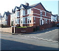
- Clicking on the map will re-center to the selected point.
- The higher the marker number, the further away the image location is from the centre of the postcode.
Image Listing (284 Images Found)
Images are licensed for reuse under creativecommons.org/licenses/by-sa/2.0
Image
Details
Distance
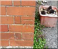
1
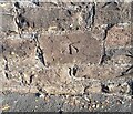
Ordnance Survey Cut Mark
This OS cut mark can be found on the wall of Clewer Court, Oakfield Road. It marks a point 63.108m above mean sea level.
Image: © Adrian Dust
Taken: 4 Aug 2021
0.01 miles
2
Ivy Road, Newport
A short name for a short road. Seen here from Oakfield Road looking towards Bryngwyn Road.
Image: © Jaggery
Taken: 20 Dec 2009
0.03 miles
3
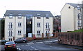
Cwrt Maes y Llyn, Newport
Modern apartment building located on Bryngwyn Road. Viewed from Ivy Road.
Image: © Jaggery
Taken: 20 Dec 2009
0.03 miles
4
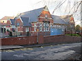
Clytha Primary School, Newport
Located on Bryngwyn Road. School motto
"To lift ourselves and others into our best possible futures"
Image: © Jaggery
Taken: 20 Dec 2009
0.03 miles
5
Corner of Llwynderi Road and Oakfield Road, Newport
Viewed across Oakfield Road.
Image: © Jaggery
Taken: 2 Mar 2011
0.03 miles
6
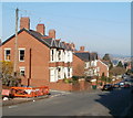
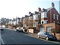
Newport : Oakfield Road houses between Tyllwyd Road and Llwynderi Road
Houses on the north side of the road. The left turn is into Tyllwyd Road.
Image: © Jaggery
Taken: 2 Mar 2011
0.03 miles
7
Oakfield Road, Newport
The southern end of Oakfield Road viewed across Risca Road. A bus stop is on the right.
Image: © Jaggery
Taken: 26 Jun 2017
0.03 miles
8
Ordnance Survey Cut Mark
This OS cut mark can be found on the north angle of the school. It marks a point 57.705m above mean sea level.
Image: © Adrian Dust
Taken: 17 Jun 2018
0.04 miles
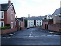
9
Houses near the top end of Oakfield Road, Newport
Houses on the north side of Oakfield Road viewed from the corner of Ivy Road.
Beyond the row of four houses nearest the camera is the right turn into Tyllwyd Road. At the left edge of the view is Clewer Court.
Image: © Jaggery
Taken: 2 Mar 2011
0.05 miles
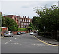
10
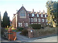
Clewer Court, Newport
Located at the top (Risca Road) end of Oakfield Road. Built as an orphanage in 1906, Clewer Court was converted into flats several decades ago, certainly before the mid 1960s. The flats are numbered 1-12, 12a, 14-24. The numbering 12a appears to be an example of triskaidekaphobia.
Image: © Jaggery
Taken: 2 Mar 2011
0.05 miles