IMAGES TAKEN NEAR TO
Llanthewy Road, NEWPORT, NP20 4LD
Introduction
This page details the photographs taken nearby to Llanthewy Road, NP20 4LD by members of the Geograph project.
The Geograph project started in 2005 with the aim of publishing, organising and preserving representative images for every square kilometre of Great Britain, Ireland and the Isle of Man.

There are currently over 7.5m images from over14,400 individuals and you can help contribute to the project by visiting https://www.geograph.org.uk
Image Map
Images are licensed for reuse under creativecommons.org/licenses/by-sa/2.0
Notes
- Clicking on the map will re-center to the selected point.
- The higher the marker number, the further away the image location is from the centre of the postcode.
Image Listing (476 Images Found)
Images are licensed for reuse under creativecommons.org/licenses/by-sa/2.0
Image
Details
Distance
1
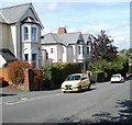
Newport : west side of lower Caerau Road
There is a big contrast between opposite sides of the lower part of Caerau Road.
The west side, as represented by the view shown here, consists of large houses set back from the roadway and separated from it by hedges. Compare with the long row of houses set close to the roadway on the opposite side. http://www.geograph.org.uk/photo/2031260
Image: © Jaggery
Taken: 22 Aug 2010
0.04 miles
2
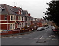
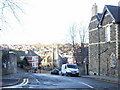
Llanthewy Road NE of Burleigh Road, Newport
Llanthewy Road descends towards the Bryngwyn Road junction.
Image: © Jaggery
Taken: 2 Dec 2013
0.05 miles
3
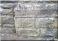
Ordnance Survey Cut Mark
This OS cut mark can be found on the Baptist Church on Llanthewy Road. It marks a point 47.686m above mean sea level.
Image: © Adrian Dust
Taken: 17 Jun 2018
0.06 miles
4
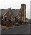
Iglesia Ni Cristo, Newport
The building on the corner of Llanthewy Road and Burleigh Road was opened as Llanthewy Road Baptist Church in 1912. The church closed in 1996 and was later used as the Burleigh Academy. The building was Grade II listed in 1998. The Philippines-based Iglesia Ni Cristo, (Church of Christ) has renovated the building and returned it to religious usage. It was rededicated on August 23rd 2012.
Image: © Jaggery
Taken: 2 Dec 2013
0.06 miles
5
Spencer Road, Newport
Spencer Road descends from Caerau Road towards Llanthewy Road.
Image: © Jaggery
Taken: 20 Dec 2009
0.06 miles
6
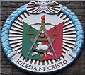
Iglesia Ni Cristo crest, Newport
The crest can be seen here http://www.geograph.org.uk/photo/3765471 centre right near the tower.
Image: © Jaggery
Taken: 2 Dec 2013
0.06 miles
7

Tower of Iglesia Ni Cristo, Newport
Located on the corner of Llanthewy Road and Burleigh Road.
http://www.geograph.org.uk/photo/3765471 to another view of the church and some details.
Image: © Jaggery
Taken: 2 Dec 2013
0.06 miles
8

Caerleon House Hotel, Newport
The hotel is a substantial former private residence at 61 Caerau Road, opposite Clyffard Crescent. There are 7 guest rooms, all with en-suite facilities.
Image: © Jaggery
Taken: 21 Aug 2010
0.07 miles
9

Underwood Insurance Services Ltd, Newport
Premises at 58 Caerau Road. Insurance services offered include personal, business, travel, overseas property, and insurance for social clubs.
Image: © Jaggery
Taken: 21 Aug 2010
0.07 miles
10

Clyffard Crescent, Newport
Viewed across Caerau Road.
Image: © Jaggery
Taken: 21 Aug 2010
0.07 miles