IMAGES TAKEN NEAR TO
Bryngwyn Road, NEWPORT, NP20 4JT
Introduction
This page details the photographs taken nearby to Bryngwyn Road, NP20 4JT by members of the Geograph project.
The Geograph project started in 2005 with the aim of publishing, organising and preserving representative images for every square kilometre of Great Britain, Ireland and the Isle of Man.

There are currently over 7.5m images from over14,400 individuals and you can help contribute to the project by visiting https://www.geograph.org.uk
Image Map
Images are licensed for reuse under creativecommons.org/licenses/by-sa/2.0
Notes
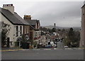
- Clicking on the map will re-center to the selected point.
- The higher the marker number, the further away the image location is from the centre of the postcode.
Image Listing (307 Images Found)
Images are licensed for reuse under creativecommons.org/licenses/by-sa/2.0
Image
Details
Distance
1
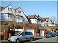
Oakfield Road houses, Newport
Houses on the north side of the road, between Llwynderi Road and Westfield Road.
Image: © Jaggery
Taken: 2 Mar 2011
0.04 miles
2
Newport : Oakfield Road houses near Llwynderi Road
Houses on the north side of Oakfield Road, viewed from opposite the turning into Llwynderi Road.
Image: © Jaggery
Taken: 2 Mar 2011
0.04 miles
3
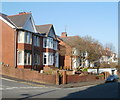
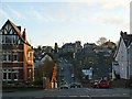
Hilla Road, Newport
Hilla Road, viewed from Burleigh Road, rises away from Bryngwyn Road towards Oakfield Road and Westfield Road.
Image: © Jaggery
Taken: 20 Dec 2009
0.05 miles
4
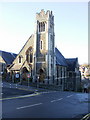
Burleigh Academy, Newport
On the corner of Llanthewy Road and Burleigh Road. Grade II listed, the premises were formerly known as Llanthewy Road Baptist Church and were last used as such in January 1997.
Burleigh Academy is a dance school.
Image: © Jaggery
Taken: 20 Dec 2009
0.05 miles
5
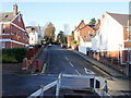
Burleigh Road, Newport
Looking down Burleigh Road, across Bryngwyn Road, towards Hilla Road.
Image: © Jaggery
Taken: 20 Dec 2009
0.05 miles
6
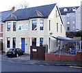
Burleigh House Day Nursery, Newport
Located at 25 Bryngwyn Road. Established in January 1992.
Image: © Jaggery
Taken: 20 Dec 2009
0.05 miles
7
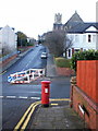
Edward VII postbox on the corner of Hilla Road and Bryngwyn Road, Newport
The view up Burleigh Road from Hilla Road, across Bryngwyn Road.
Image: © Jaggery
Taken: 20 Dec 2009
0.05 miles
8
Hilla Road
From the junction with Oakfield Road, looking down Hilla Road with Burleigh Road and Spencer Road rising up. For the reverse view see http://www.geograph.org.uk/photo/1430677 .
Image: © Robin Drayton
Taken: 18 Dec 2009
0.06 miles
9
Manley Road, Newport
Manley Road descends from Risca Road.
The steepest part of the road is the few metres beyond the junction.
The Civic Centre clock tower is in the distance.
Image: © Jaggery
Taken: 10 Jan 2017
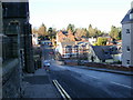
0.06 miles
10
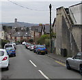
Bolton Road, Newport
Bolton Road descends from Risca Road towards Manley Road.
The Civic Centre clock tower http://www.geograph.org.uk/photo/2198118 is in the background.
Image: © Jaggery
Taken: 19 Mar 2016
0.06 miles