IMAGES TAKEN NEAR TO
Bryngwyn Road, NEWPORT, NP20 4JS
Introduction
This page details the photographs taken nearby to Bryngwyn Road, NP20 4JS by members of the Geograph project.
The Geograph project started in 2005 with the aim of publishing, organising and preserving representative images for every square kilometre of Great Britain, Ireland and the Isle of Man.

There are currently over 7.5m images from over14,400 individuals and you can help contribute to the project by visiting https://www.geograph.org.uk
Image Map
Images are licensed for reuse under creativecommons.org/licenses/by-sa/2.0
Notes
- Clicking on the map will re-center to the selected point.
- The higher the marker number, the further away the image location is from the centre of the postcode.
Image Listing (425 Images Found)
Images are licensed for reuse under creativecommons.org/licenses/by-sa/2.0
Image
Details
Distance
1
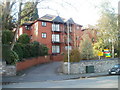
Aragon House, Oakfield Road, Newport
Three-storey building, near the eastern end of Oakfield Road, containing 14 flats.
Image: © Jaggery
Taken: 2 Mar 2011
0.03 miles
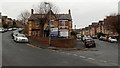
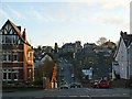
2
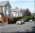
Up Bryngwyn Road, Newport
Bryngwyn Road ascends from Llanthewy Road towards Risca Road.
Image: © Jaggery
Taken: 14 Oct 2018
0.04 miles
3
Llanthewy Road NE of Burleigh Road, Newport
Llanthewy Road descends towards the Bryngwyn Road junction.
Image: © Jaggery
Taken: 2 Dec 2013
0.05 miles
4
Newport : west side of lower Caerau Road
There is a big contrast between opposite sides of the lower part of Caerau Road.
The west side, as represented by the view shown here, consists of large houses set back from the roadway and separated from it by hedges. Compare with the long row of houses set close to the roadway on the opposite side. http://www.geograph.org.uk/photo/2031260
Image: © Jaggery
Taken: 22 Aug 2010
0.06 miles
5
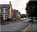
Office suites to let in Llanthewy Road, Newport
The suites to let are in number 10 Llanthewy Road, on the left. The right side is Heron House, number 1 Bryngwyn Road. The nameboard shows hhfm, a trading name of Heron House Financial Management Limited.
Image: © Jaggery
Taken: 2 Dec 2013
0.06 miles
6
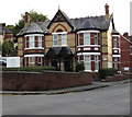
Heron House, 1 Bryngwyn Road, Newport
Heron House on the right is the office of Heron House Financial Management Limited.
Image: © Jaggery
Taken: 14 Oct 2018
0.06 miles
7
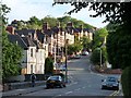
Llanthewy Road
Viewed from near to the Civic Centre.
The top of the road is at the Handpost http://www.geograph.org.uk/photo/903546 .
Image: © Robin Drayton
Taken: 26 Jul 2010
0.07 miles
8
Up Llanthewy Road, Newport
Llanthewy Road ascends towards Risca Road and the Handpost area of Newport.
The broken white lines are at the Bryngwyn Road junction.
Image: © Jaggery
Taken: 14 Oct 2018
0.07 miles
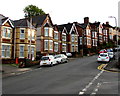
9
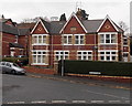
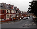
Late Victorian houses, Bryngwyn Road, Newport
The year 1896 is inscribed on the central gable of the semi-detached
houses at the NE end of Bryngwyn Road, viewed from Llanthewy Road.
Image: © Jaggery
Taken: 2 Dec 2013
0.08 miles
10
Hilla Road
From the junction with Oakfield Road, looking down Hilla Road with Burleigh Road and Spencer Road rising up. For the reverse view see http://www.geograph.org.uk/photo/1430677 .
Image: © Robin Drayton
Taken: 18 Dec 2009
0.08 miles