IMAGES TAKEN NEAR TO
Risca Road, NEWPORT, NP20 4HY
Introduction
This page details the photographs taken nearby to Risca Road, NP20 4HY by members of the Geograph project.
The Geograph project started in 2005 with the aim of publishing, organising and preserving representative images for every square kilometre of Great Britain, Ireland and the Isle of Man.

There are currently over 7.5m images from over14,400 individuals and you can help contribute to the project by visiting https://www.geograph.org.uk
Image Map
Images are licensed for reuse under creativecommons.org/licenses/by-sa/2.0
Notes
- Clicking on the map will re-center to the selected point.
- The higher the marker number, the further away the image location is from the centre of the postcode.
Image Listing (307 Images Found)
Images are licensed for reuse under creativecommons.org/licenses/by-sa/2.0
Image
Details
Distance
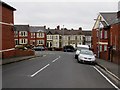
1
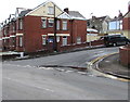
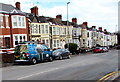
Corner of Risca Road and Upton Road, Newport
Viewed across Risca Road on March 19th 2018. Traces of the light snowfall
overnight on the 17th-18th remain on roofs and on and near the brick walls.
Image: © Jaggery
Taken: 19 Mar 2018
0.02 miles
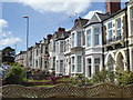
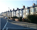
3
Row of houses, Risca Road, Newport
On the north side of Risca Road, west of the Oakfield Road junction.
Image: © Jaggery
Taken: 19 Mar 2016
0.02 miles
4
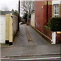
Ombersley Lane, Newport
Viewed from Upton Road. This is the western end of Ombersley Lane which leads to Bassaleg Road
about 250 metres ahead. Ombersley Lane is parallel with Ombersley Road, 45 metres to the south.
Image: © Jaggery
Taken: 19 Mar 2016
0.02 miles
5
Northern end of Upton Road, Newport
Upton Road descends towards Risca Road.
Image: © Jaggery
Taken: 19 Mar 2016
0.02 miles
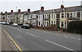
6
Newport : Risca Road houses adjacent to Oakfield Road
Houses on the north side of Risca Road (B4591) viewed across the junction with Oakfield Road.
Image: © Jaggery
Taken: 2 Mar 2011
0.03 miles
7
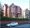
The Vicarage, Oakfield Road, Newport
Located at the top (Risca Road) end of Oakfield Road, next door to Clewer Court. http://www.geograph.org.uk/photo/2291612
It is the vicarage for St John the Baptist's Church in Wales Church, http://www.geograph.org.uk/photo/2523056 located nearby on Risca Road.
Image: © Jaggery
Taken: 2 Mar 2011
0.03 miles
8
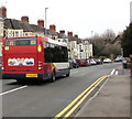
Stagecoach bus, Risca Road, Newport
The Stagecoach single-decker, fleet number 47696, is on route R1
from Risca to Market Square bus station in the centre of Newport.
Image: © Jaggery
Taken: 19 Mar 2016
0.03 miles
9
Sky van, Risca Road, Newport
In March 2018 the van depicts scenes from the Animal Planet channel.
Text on the van includes the slogan Believe in better.
Image: © Jaggery
Taken: 19 Mar 2018
0.03 miles
10
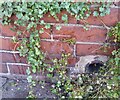
Ordnance Survey Cut Mark
This OS cut mark can be found on No2 Upton Road. It marks a point 75.242m above mean sea level.
Image: © Adrian Dust
Taken: 4 Aug 2021
0.03 miles