IMAGES TAKEN NEAR TO
Stow Hill, NEWPORT, NP20 4HB
Introduction
This page details the photographs taken nearby to Stow Hill, NP20 4HB by members of the Geograph project.
The Geograph project started in 2005 with the aim of publishing, organising and preserving representative images for every square kilometre of Great Britain, Ireland and the Isle of Man.

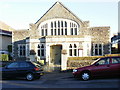
There are currently over 7.5m images from over14,400 individuals and you can help contribute to the project by visiting https://www.geograph.org.uk
Image Map
Images are licensed for reuse under creativecommons.org/licenses/by-sa/2.0
Notes
- Clicking on the map will re-center to the selected point.
- The higher the marker number, the further away the image location is from the centre of the postcode.
Image Listing (391 Images Found)
Images are licensed for reuse under creativecommons.org/licenses/by-sa/2.0
Image
Details
Distance
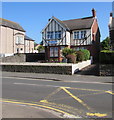
1
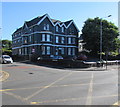
Stow Park Court, Stow Hill, Newport
Flats at 200 Stow Hill on the corner of Caerau Road.
Image: © Jaggery
Taken: 26 Jun 2018
0.00 miles
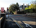
2
White arrows painted on Caerau Road, Newport
Showing drivers which lane to be in for the Stow Hill and Stow Park Crescent crossroads junction ahead.
There are two lanes here for vehicles towards the junction, one lane for vehicles from the junction.
Image: © Jaggery
Taken: 21 Nov 2015
0.02 miles
3
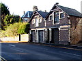
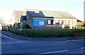
Lockup garages, Caerau Road, Newport
These stone buildings date from the late 19th century, which suggests that they were built as horse stables.
Image: © Jaggery
Taken: 21 Nov 2015
0.02 miles
4
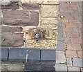
Ordnance Survey Cut Mark
This OS cut mark can be found on No204 Caerau Road.
Image: © Adrian Dust
Taken: 17 Jun 2018
0.02 miles
5
Stow Park Church, Newport
Located on Brynhyfryd Road, near the Stow Hill junction. The church was built in 1908. In its centenary year, 2008, the congregations of Stow Park Presbyterian Chapel and Newport United Reformed Church united to worship together here. Next to the church is the old church hall. http://www.geograph.org.uk/photo/1629409
Image: © Jaggery
Taken: 20 Dec 2009
0.02 miles
6
Stow Park Church Hall, Newport
On the corner of Stow Hill and Brynhyfryd Road, next to Stow Park Church. http://www.geograph.org.uk/photo/1629402
The intention is to demolish this old and unusable hall and to construct a modern, multi-purpose building in its place.
UPDATE November 2010. The hall has been demolished. A new one is under construction. http://www.geograph.org.uk/photo/2170682
UPDATE January 2011. The new Church Centre http://www.geograph.org.uk/photo/2232081 is in use.
Image: © Jaggery
Taken: 20 Dec 2009
0.02 miles
7
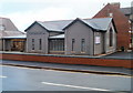
Stow Park Church Centre, Newport
The Church Centre was built in 2010, replacing an old church hall. http://www.geograph.org.uk/photo/1629409
Viewed across Brynhyfryd Road, near the corner of Stow Hill.
On the left is the edge of Stow Park Church. http://www.geograph.org.uk/photo/1629402
Image: © Jaggery
Taken: 14 Jan 2011
0.02 miles
8

Junction of Caerau Road and Stow Hill, Newport
The B4591 Caerau Road viewed across the B4240 Stow Hill from the corner of Stow Park Crescent.
Image: © Jaggery
Taken: 25 May 2017
0.02 miles
9
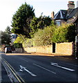
Glen Roy Hotel, Stow Hill, Newport
Hotel at 192 Stow Hill viewed from the corner of Stow Park Avenue.
Image: © Jaggery
Taken: 25 May 2017
0.02 miles
10
Junction of Caerau Road and Stow Hill, Newport
Traffic lights control this junction at the southern end of Caerau Road, in the Stow Park area of Newport.
Caerau Road's northern end is about 550 metres behind the camera, at the Clytha Park Road junction.
Image: © Jaggery
Taken: 21 Nov 2015
0.03 miles