IMAGES TAKEN NEAR TO
Clyffard Crescent, NEWPORT, NP20 4GE
Introduction
This page details the photographs taken nearby to Clyffard Crescent, NP20 4GE by members of the Geograph project.
The Geograph project started in 2005 with the aim of publishing, organising and preserving representative images for every square kilometre of Great Britain, Ireland and the Isle of Man.

There are currently over 7.5m images from over14,400 individuals and you can help contribute to the project by visiting https://www.geograph.org.uk
Image Map
Images are licensed for reuse under creativecommons.org/licenses/by-sa/2.0
Notes
- Clicking on the map will re-center to the selected point.
- The higher the marker number, the further away the image location is from the centre of the postcode.
Image Listing (938 Images Found)
Images are licensed for reuse under creativecommons.org/licenses/by-sa/2.0
Image
Details
Distance
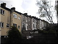
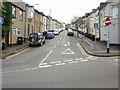
1

East side of Clyffard Crescent, Newport
This is the section of Clyffard Crescent between Kingsmill Terrace (behind the camera) and Windsor Terrace.
Image: © Jaggery
Taken: 21 Aug 2010
0.02 miles
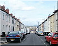
2
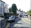
Windsor Terrace, Newport
Houses on the west side of Windsor Terrace, viewed from the Clyffard Crescent end.
Image: © Jaggery
Taken: 22 Aug 2010
0.02 miles
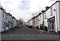
3
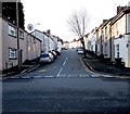
Up St Woolos Road, Baneswell, Newport
St Woolos Road ascends from St Mary Street towards Clifton Road, out of shot 235 metres ahead.
Several dead-end streets connect with the west (right) side of St Woolos Road.
Image: © Jaggery
Taken: 21 Nov 2015
0.04 miles
4
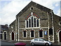
St Mary Street Baptist church,Baneswell,Newport
Located near the junction with St Edward Street, this church has been a landmark in Baneswell for more than a century.
Image: © Jaggery
Taken: 13 Aug 2009
0.04 miles
5
St Edward Street, Newport
Looking up St Edward Street,Baneswell from St Mary Street.
Image: © Jaggery
Taken: 13 Aug 2009
0.04 miles
6
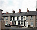
Oddfellows & Foresters Arms, Baneswell, Newport
In St Mary Street opposite St Woolos Road in the Baneswell area of Newport.
Update November 2015. The pub has gone. http://www.geograph.org.uk/photo/4747533
Image: © Jaggery
Taken: 13 Aug 2009
0.04 miles
7

Sunday School, St Mary Street, Newport
Located next door to St Mary Street Baptist church. http://www.geograph.org.uk/photo/1457880
A stone inscription above the red door reads
Sunday School
Peace Memorial
1929
The building is probably currently used as a church hall.
Image: © Jaggery
Taken: 21 Aug 2010
0.04 miles
8
The view from the far end of St Edward Street, Newport
Looking towards St Mary Street from the far end of St Edward Street. Although the street is a cul-de-sac, Edward Lane http://www.geograph.org.uk/photo/2024788 provides pedestrian access from the far end of the street to the far end of two adjacent streets.
Image: © Jaggery
Taken: 22 Aug 2010
0.04 miles
9
Up Blewitt Street, Baneswell, Newport
Viewed across East Street looking past Knights http://www.geograph.org.uk/photo/3954025 on the right and Mongolian BBQ http://www.geograph.org.uk/photo/3953937 on the left.
Image: © Jaggery
Taken: 27 Apr 2014
0.05 miles