IMAGES TAKEN NEAR TO
Brynhyfryd Avenue, NEWPORT, NP20 4FY
Introduction
This page details the photographs taken nearby to Brynhyfryd Avenue, NP20 4FY by members of the Geograph project.
The Geograph project started in 2005 with the aim of publishing, organising and preserving representative images for every square kilometre of Great Britain, Ireland and the Isle of Man.

There are currently over 7.5m images from over14,400 individuals and you can help contribute to the project by visiting https://www.geograph.org.uk
Image Map
Images are licensed for reuse under creativecommons.org/licenses/by-sa/2.0
Notes
- Clicking on the map will re-center to the selected point.
- The higher the marker number, the further away the image location is from the centre of the postcode.
Image Listing (551 Images Found)
Images are licensed for reuse under creativecommons.org/licenses/by-sa/2.0
Image
Details
Distance
1
Graham Street, Baneswell, Newport
Viewed from the corner of St Woolos Road.
http://www.geograph.org.uk/photo/2024763 to a view in the opposite direction.
Image: © Jaggery
Taken: 16 Nov 2009
0.03 miles
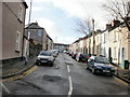
2
York Place, Newport
The view along the middle section of York Place, which descends from Stow Hill. Formerly the roadway connected with Clyffard Crescent, but now there is only a footpath connection.
Image: © Jaggery
Taken: 20 Dec 2009
0.03 miles
3
Grade II listed transformer, Graham Street, Newport
Viewed from Edward Lane, the dark blue structure is Grade II listed by Cadw, (the historic environment service of the Welsh Assembly Government. Its Cadw reference is 3061, and it is described as "Electricity Transformer at SW end of Graham Street". It is late 19th century, with a circular cast iron case, moulded panel work and decoration.
Somewhat surprisingly perhaps, it is topped with a modern street light and it has an identity number similar to ordinary lamp posts nearby. However, my dedication to complete the research did not extend to waiting here (on a day of frequent showers) for sunset, which was more than 6 hours away, to confirm whether or not it is in use a street light.
Image: © Jaggery
Taken: 21 Aug 2010
0.03 miles
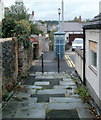
4

Edward Lane, Newport
Edward Lane connects the far ends of three cul-de-sacs in Baneswell, Newport.
This view is from the far end of Graham Street looking towards St Julian Street.
Image: © Jaggery
Taken: 21 Aug 2010
0.03 miles
5

Steps in Edward Lane, Newport
Edward Lane connects the far end of three cul-de-sacs in Baneswell, Newport.
This view is from near the far end of St Edward Street, looking towards a Grade II listed transformer http://www.geograph.org.uk/photo/2024728 at the far end of Graham Street. Edward Lane continues http://www.geograph.org.uk/photo/2024753 beyond the transformer to the far end of St Julian Street.
Image: © Jaggery
Taken: 21 Aug 2010
0.03 miles
6

Pavement drainage channel, St Edward Street, Newport
St Edward Street retains a feature that was probably typical of Victorian streets in the area. On the west side of the street, a drainage channel runs between a steepish slope in the pavement from the roadside and a less steep slope from the side of the houses. There is no similar channel on the opposite side of the street.
Image: © Jaggery
Taken: 22 Aug 2010
0.04 miles
7

Modern housing, Graham Street, Newport
Most of Graham Street is Victorian terraced housing. The exception is this group of modern dwellings, at the top end of the street.
Image: © Jaggery
Taken: 22 Aug 2010
0.04 miles
8
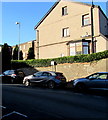
Brynhyfryd Avenue parking area, Newport
The notice on a pole states that parking is allowed for up to 2 hours.
No return within 2 hours except for holders of Y1 resident permits.
Image: © Jaggery
Taken: 21 Nov 2015
0.04 miles
9
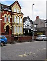
St Etienne hotel/guest house, 162 Stow Hill, Newport
The name above the doorway on the left is St Etienne Hotel.
The name on the green sign on the wall is St Etienne Guest House.
Image: © Jaggery
Taken: 19 Mar 2018
0.05 miles
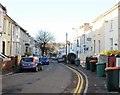
10
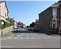
Junction of Brynhyfryd Avenue and Stow Hill, Newport
The southern end of Brynhyfryd Avenue viewed across Stow Hill.
Image: © Jaggery
Taken: 25 May 2017
0.05 miles