1
Yellow grit and salt box on the corner of Waterloo Road and Llandaff Street, Newport
The contents of the box are used to treat the road surface in snowy or icy weather. The fairly flat area in view is not typical of the roads nearby. Llandaff Street on the right descends steeply towards Coldra Road and Waterloo Road to the left descends steeply towards Cardiff Road.
Image: © Jaggery
Taken: 11 Jul 2016
0.01 miles
2
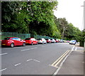
On-street parking, Waterloo Road, Newport
On the Belle Vue Park side of the road. The Llandaff Street junction is on the right.
Image: © Jaggery
Taken: 13 Jul 2016
0.01 miles
3
Northern end of Waterloo Road, Newport
Viewed from an access road to Belle Vue Park. This part of Waterloo Road is between the Llandaff Street junction on the left, and the Stow Park Avenue and Friars Road junctions out of shot on the right. Ashton Park residential care home http://www.geograph.org.uk/photo/5288602 is on the right.
Image: © Jaggery
Taken: 11 Jul 2016
0.02 miles
4
Llandaff Street, Newport
At the top of Coldra Road, the road turns at a right angle into Llandaff Street as it rises very steeply towards Waterloo Road. Trees at the edge of Belle Vue Park can be seen at the top of the view
Image: © Jaggery
Taken: 13 Aug 2009
0.02 miles
5
Children's play area, Belle Vue Park, Newport
Located on a narrow flat terrace on sloping ground. The previous play area, much used during the childhood of this contributor decades ago, was lower down the park, adjacent to the Cardiff Road edge of the park.
Image: © Jaggery
Taken: 26 Nov 2009
0.02 miles
6
Restoration work planned for fire-damaged tea house, Newport
Newport City Council announced in December 2010 that it intends to tender for the work needed to restore this Grade II listed rustic tea house in Belle Vue Park. It was damaged in an arson attack in August 2010.
UPDATE 2012 The restored teahouse has reopened. http://www.geograph.org.uk/photo/2833403
Image: © Jaggery
Taken: 29 Apr 2011
0.02 miles
7
An entrance to Belle Vue Park, Newport
This entrance faces Stow Park Avenue, at the junction with Friars Road (left) and Waterloo Road.
Image: © Jaggery
Taken: 13 Aug 2011
0.02 miles
8
Lower end of Stow Park Avenue, Newport
Stow Park Avenue ends at the junction with Friars Road (to the left) and Waterloo Road (to the right).
If you continue straight ahead, you enter Belle Vue Park.
Image: © Jaggery
Taken: 13 Aug 2011
0.02 miles
9
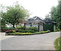
Restored tea house, Belle Vue Park, Newport
Located near the Waterloo Road side of Belle Vue Park, the restored tea house was officially reopened by Newport mayor Margaret Cornelious and cabinet member for leisure and culture Mike Hamilton on Thursday February 23rd 2012, after about £70,000 of restoration work funded by insurance.
The building had been severely damaged http://www.geograph.org.uk/photo/2390197 in an arson attack in August 2010.
Image: © Jaggery
Taken: 3 Mar 2012
0.02 miles
10
Ordnance Survey Cut Mark
This OS cut mark can be found on the wall SE side of Waterloo Road. It marks a point 37.056m above mean sea level.
Image: © Adrian Dust
Taken: 9 Jun 2018
0.02 miles


