IMAGES TAKEN NEAR TO
Llandaff Street, NEWPORT, NP20 4FG
Introduction
This page details the photographs taken nearby to Llandaff Street, NP20 4FG by members of the Geograph project.
The Geograph project started in 2005 with the aim of publishing, organising and preserving representative images for every square kilometre of Great Britain, Ireland and the Isle of Man.

There are currently over 7.5m images from over14,400 individuals and you can help contribute to the project by visiting https://www.geograph.org.uk
Image Map
Images are licensed for reuse under creativecommons.org/licenses/by-sa/2.0
Notes
- Clicking on the map will re-center to the selected point.
- The higher the marker number, the further away the image location is from the centre of the postcode.
Image Listing (418 Images Found)
Images are licensed for reuse under creativecommons.org/licenses/by-sa/2.0
Image
Details
Distance
1
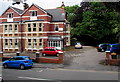
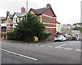
Ashton Park, Newport
Residential care home at 36-37 Waterloo Road, opposite Belle Vue Park.
Image: © Jaggery
Taken: 11 Jul 2016
0.03 miles
2
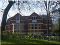
Residential Care Home, Waterloo Road , Newport
Viewed from Belle Vue Park.
Image: © Robin Drayton
Taken: 24 Feb 2017
0.03 miles
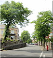
3
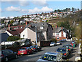
Llandaff Street
A footpath at the bottom of the street drops down into a cutting where there is a footbridge which crosses the South Wales main line railway. The path can be seen climbing up through some allotments to Caer Perllan Road.
Image: © Robin Drayton
Taken: 27 Mar 2008
0.03 miles
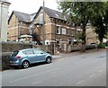
4
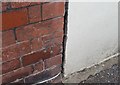
Ordnance Survey Cut Mark
This OS cut mark can be found on No67 Coldra Road. It marks a point 28.106m above mean sea level.
Image: © Adrian Dust
Taken: 9 Jun 2018
0.03 miles
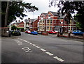
5
Yellow grit and salt box on the corner of Waterloo Road and Llandaff Street, Newport
The contents of the box are used to treat the road surface in snowy or icy weather. The fairly flat area in view is not typical of the roads nearby. Llandaff Street on the right descends steeply towards Coldra Road and Waterloo Road to the left descends steeply towards Cardiff Road.
Image: © Jaggery
Taken: 11 Jul 2016
0.03 miles
6
Northern end of Waterloo Road, Newport
Viewed from an access road to Belle Vue Park. This part of Waterloo Road is between the Llandaff Street junction on the left, and the Stow Park Avenue and Friars Road junctions out of shot on the right. Ashton Park residential care home http://www.geograph.org.uk/photo/5288602 is on the right.
Image: © Jaggery
Taken: 11 Jul 2016
0.03 miles
7
Tree-lined Stow Park Avenue, Newport
Looking up Stow Park Avenue from the corner of Friars Road and Waterloo Road.
Image: © Jaggery
Taken: 30 May 2010
0.04 miles
8
Sunnybank Day Nursery, Stow Park Avenue, Newport
Day nursery for children aged 5 and younger. The nursery is located at the lower end of the Avenue, near the Friars Road / Waterloo Road junction.
Image: © Jaggery
Taken: 13 Aug 2011
0.04 miles
9
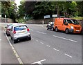
Orange van in Waterloo Road, Newport
Parked near an entrance to Belle Vue Park.
The Friars Road and Stow Park Avenue junctions are in the background.
Image: © Jaggery
Taken: 13 Jul 2016
0.04 miles
10

Burton Alms Houses, Newport
On Friars Road, near the junction with Waterloo Road and Stow Park Avenue. The Alms Houses continue http://www.geograph.org.uk/photo/1472559 beyond the right edge of the photo.
Image: © Jaggery
Taken: 13 Aug 2009
0.04 miles