IMAGES TAKEN NEAR TO
Coldra Road, NEWPORT, NP20 4FF
Introduction
This page details the photographs taken nearby to Coldra Road, NP20 4FF by members of the Geograph project.
The Geograph project started in 2005 with the aim of publishing, organising and preserving representative images for every square kilometre of Great Britain, Ireland and the Isle of Man.

There are currently over 7.5m images from over14,400 individuals and you can help contribute to the project by visiting https://www.geograph.org.uk
Image Map
Images are licensed for reuse under creativecommons.org/licenses/by-sa/2.0
Notes
- Clicking on the map will re-center to the selected point.
- The higher the marker number, the further away the image location is from the centre of the postcode.
Image Listing (408 Images Found)
Images are licensed for reuse under creativecommons.org/licenses/by-sa/2.0
Image
Details
Distance
1
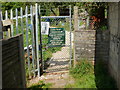
Coldra Road allotments, Newport
Padlocked entrance.
Image: © Jaggery
Taken: 13 Aug 2009
0.01 miles
2
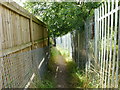
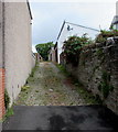
Footpath connecting allotments
The footpath descends from the entrance to Coldra Road allotments , across a railway bridge to the two entrances to Cae Perllan allotments. The path surface is very rough, being composed of broken bricks and stones.
Image: © Jaggery
Taken: 13 Aug 2009
0.01 miles
3
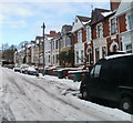
The top end of Waterloo Road, Newport
Waterloo Road houses near the corner of Llandaff Street. A few metres ahead, Waterloo Road ends at the V-shaped junction of Stow Park Avenue and Friars Road.
On the camera side of the road is the western edge of Belle Vue Park.
Image: © Jaggery
Taken: 30 May 2010
0.01 miles
4
Coldra Road houses, Newport
Houses in the top half of the east side of the road. The view is looking towards the right-angle turn into Llandaff Street.
Image: © Jaggery
Taken: 24 Dec 2010
0.01 miles
5
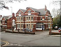
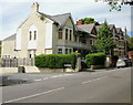
Ashton Park care home, Newport
Viewed from an entrance to Belle Vue Park. Ashton Park, 36-37 Waterloo Road, is a privately-owned care home for 20 residents.
Image: © Jaggery
Taken: 1 Apr 2011
0.01 miles
6
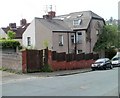
Corner house at the top of Coldra Road, Newport
The corner house at the top end of Coldra Road extends towards the camera along Llandaff Street and the edge of Gaer Lane. The year prominently displayed on the property (behind the tree) is 1894.
Image: © Jaggery
Taken: 29 Apr 2011
0.01 miles
7
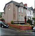
Late Victorian houses at the top end of Coldra Road, Newport
Viewed from the corner of Llandaff Street. The year 1894 is shown on the side wall of the corner property.
Image: © Jaggery
Taken: 13 Aug 2012
0.01 miles
8
Llandaff Street
A footpath at the bottom of the street drops down into a cutting where there is a footbridge which crosses the South Wales main line railway. The path can be seen climbing up through some allotments to Caer Perllan Road.
Image: © Robin Drayton
Taken: 27 Mar 2008
0.02 miles
9
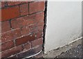
Ordnance Survey Cut Mark
This OS cut mark can be found on No67 Coldra Road. It marks a point 28.106m above mean sea level.
Image: © Adrian Dust
Taken: 9 Jun 2018
0.02 miles
10
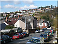
Up Gaer Lane, Newport
Gaer Lane ascends for 200 metres from Gaer Street to Llandaff Street, between the backs
of Coldra Road houses on the left and the backs of Waterloo Road houses on the right.
The satellite dish seen in this July 2016 photo was not there in August 2009. http://www.geograph.org.uk/photo/1441364
Image: © Jaggery
Taken: 11 Jul 2016
0.03 miles