IMAGES TAKEN NEAR TO
Victoria Road, NEWPORT, NP20 4EQ
Introduction
This page details the photographs taken nearby to Victoria Road, NP20 4EQ by members of the Geograph project.
The Geograph project started in 2005 with the aim of publishing, organising and preserving representative images for every square kilometre of Great Britain, Ireland and the Isle of Man.

There are currently over 7.5m images from over14,400 individuals and you can help contribute to the project by visiting https://www.geograph.org.uk
Image Map
Images are licensed for reuse under creativecommons.org/licenses/by-sa/2.0
Notes
- Clicking on the map will re-center to the selected point.
- The higher the marker number, the further away the image location is from the centre of the postcode.
Image Listing (1753 Images Found)
Images are licensed for reuse under creativecommons.org/licenses/by-sa/2.0
Image
Details
Distance
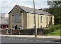
1
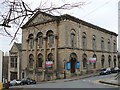
Victoria Road United Reformed Church
The days appear to be numbered for this prominent Newport chapel building. http://www.newport.gov.uk/_dc/index.cfm?fuseaction=thingstosee.churches&contentid=cont054722
Image: © Robin Drayton
Taken: 28 Jan 2008
0.00 miles
2
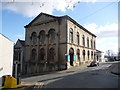
Newport: Victoria Road United Reformed Church
This church stands at the top of Hill Street (left; you can see that it really is a hill!), with Victoria Road facing us. In the gable is inscribed:
A.D.
1860
Have faith in God
Mark XI 22
Image: © Chris Downer
Taken: 22 Feb 2009
0.00 miles
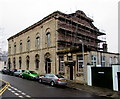
3
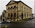
Grade II listed former Victoria Road United Reformed Church, Newport
The distinctive building is strikingly sited on the corner of Victoria Road and Hill Street.
Dated 1859, the building is in the Classical style. Grade II listed as Victoria Road United Reformed Church in 1974, the building is now (January 2015) the premises of the Islamic Society for Wales.
Image: © Jaggery
Taken: 22 Jan 2015
0.00 miles
4
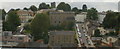
Park Square and Hill Street, Newport
Viewed from the top (7th floor) of the Kingsway Centre car park. Park Square on the left, and Hill Street on the right, both climb towards Victoria Road.
Image: © Jaggery
Taken: 4 Sep 2009
0.01 miles
5
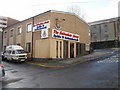
Salvation Army Citadel, Hill Street , Newport
The citadel (a meeting hall) at 1 Hill Street is one of two Salvation Army premises on Hill Street. The citadel was reconstructed in the mid-1990s using funds from the sale of the Hereford Street citadel, now a mosque. http://www.geograph.org.uk/photo/1565005
The other premises http://www.geograph.org.uk/photo/1585020 are on the steeper, higher part of Hill Street.
Image: © Jaggery
Taken: 16 Nov 2009
0.01 miles
6
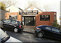
The Bridge, Salvation Army, Hill Street, Newport
Hill Street deserves its name, especially in this very steep section nearer the top. The Bridge Youth Church and Community Centre is one of two http://www.geograph.org.uk/photo/1585015 Salvation Army premises on Hill Street.
Image: © Jaggery
Taken: 16 Nov 2009
0.01 miles
7
The Welsh Church, Hill Street, Newport
Located on the corner of Hill Street and Ivor Street, built in the 1830s and rebuilt in the 1870s. Officially known as Eglwys Annibynnol Mynydd Seion, services are conducted in the Welsh language.
It is also known as Mount Zion Welsh Independent Chapel, Mount Zion Welsh Congregational Chapel, or simply The Welsh Church - indicating it is (probably) the only Welsh-language church remaining in the city.
Image: © Jaggery
Taken: 13 Jun 2010
0.01 miles
8
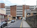
Park Square multi-storey car park, Newport
Viewed from Ivor Street.
The car park is open from 7am-7pm (Mon – Sat) - closed all day on Sundays.
There is space for 395 vehicles, including 7 disabled badge holder bays.
http://www.geograph.org.uk/photo/1332079 to a view from the top of the building.
On the left is a Salvation Army Citadel. http://www.geograph.org.uk/photo/1585015
Image: © Jaggery
Taken: 13 Jun 2010
0.01 miles
9
Victoria Road side of a Grade II Listed building, Newport
Now (January 2015) the premises of the Islamic Society for Wales, this building on the corner of Hill Street was Grade II listed as Victoria Road United Reformed Church in 1974. http://www.geograph.org.uk/photo/4319541 to another view.
Image: © Jaggery
Taken: 22 Jan 2015
0.01 miles
10
![Across the rooftops [1], Newport](https://s1.geograph.org.uk/geophotos/04/98/45/4984565_72913d43_120x120.jpg)
Across the rooftops [1], Newport
In the foreground are the backs of the shops in Commercial Street.
Hill Street http://www.geograph.org.uk/photo/673068 with cars parked on either side is in the centre.
The tower of St Woolos Cathedral is on the skyline http://www.geograph.org.uk/photo/716275 .
Taken from the top level of the Kingsway multi-storey car park.
Image: © Robin Drayton
Taken: 28 May 2016
0.02 miles