IMAGES TAKEN NEAR TO
Dewsland Park Road, NEWPORT, NP20 4EG
Introduction
This page details the photographs taken nearby to Dewsland Park Road, NP20 4EG by members of the Geograph project.
The Geograph project started in 2005 with the aim of publishing, organising and preserving representative images for every square kilometre of Great Britain, Ireland and the Isle of Man.

There are currently over 7.5m images from over14,400 individuals and you can help contribute to the project by visiting https://www.geograph.org.uk
Image Map
Images are licensed for reuse under creativecommons.org/licenses/by-sa/2.0
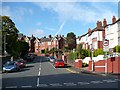
Notes
- Clicking on the map will re-center to the selected point.
- The higher the marker number, the further away the image location is from the centre of the postcode.
Image Listing (898 Images Found)
Images are licensed for reuse under creativecommons.org/licenses/by-sa/2.0
Image
Details
Distance
1
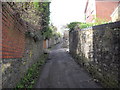
Dewsland Park Road
The lower section of this steep winding road.
Image: © Robin Drayton
Taken: 16 Oct 2008
0.03 miles
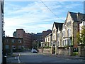
2
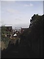
Looking down Vicarage Hill, Newport
The transporter bridge stands out in the distance.
Image: © John Lord
Taken: 30 Mar 2011
0.03 miles
3

Vicarage Hill, Newport
Vicarage Hill begins its steep climb away from Dewsland Park Road towards Stow Hill.
Image: © Jaggery
Taken: 22 Aug 2010
0.03 miles
5
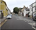
Clytha Square, Newport
The road ascends from Cardiff Road towards Dewsland Park Road.
Image: © Jaggery
Taken: 24 Jul 2016
0.06 miles
6
Top of Clytha Square
With a side entrance to the Royal Gwent Hospital.
Image: © Robin Drayton
Taken: 16 Oct 2008
0.07 miles
7
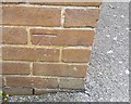
Ordnance Survey Cut Mark
This OS cut mark can be found on the Hospital Offices SW side of Clytha Square. It marks a point 20.896m above mean sea level.
Image: © Adrian Dust
Taken: 17 Jun 2018
0.07 miles
8

Dewsland Park Road houses, Newport
Houses on the eastern side of Dewsland Park Road, near one of several bends in the road on its sinuous course from Stow Hill to Keynsham Avenue.
Image: © Jaggery
Taken: 22 Aug 2010
0.07 miles
9
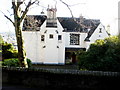
The Deanery, Stow Hill, Newport
Viewed from the elevated pavement alongside St Woolos Cathedral. The Deanery, 105 Stow Hill, is Grade II listed.
Image: © Jaggery
Taken: 20 Dec 2009
0.07 miles
10

Central section of Dewsland Park Road, Newport
A rare flat, straight section along Dewsland Park Road, which follows a mostly steep, sinuous route from Stow Hill to Keynsham Avenue.
Image: © Jaggery
Taken: 22 Aug 2010
0.07 miles