IMAGES TAKEN NEAR TO
Vicarage Hill, NEWPORT, NP20 4EB
Introduction
This page details the photographs taken nearby to Vicarage Hill, NP20 4EB by members of the Geograph project.
The Geograph project started in 2005 with the aim of publishing, organising and preserving representative images for every square kilometre of Great Britain, Ireland and the Isle of Man.

There are currently over 7.5m images from over14,400 individuals and you can help contribute to the project by visiting https://www.geograph.org.uk
Image Map
Images are licensed for reuse under creativecommons.org/licenses/by-sa/2.0
Notes
- Clicking on the map will re-center to the selected point.
- The higher the marker number, the further away the image location is from the centre of the postcode.
Image Listing (1029 Images Found)
Images are licensed for reuse under creativecommons.org/licenses/by-sa/2.0
Image
Details
Distance
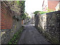
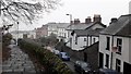
2
Looking down Vicarage Hill, Newport
The transporter bridge stands out in the distance.
Image: © John Lord
Taken: 30 Mar 2011
0.03 miles
3
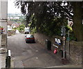
Vicarage Hill, Newport
Vicarage Hill gives a direct, steep route from Stow Hill on this side to Dewsland Park Road about 160 metres away.
Image: © Jaggery
Taken: 18 Jul 2014
0.03 miles
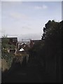
4
Newport: Vicarage Hill
Looking down this very steep path which descends towards the city centre from the cathedral.
Image: © Chris Downer
Taken: 17 Feb 2008
0.03 miles
5
Stow Hill from St Woolos' churchyard
Stow Hill curves and climbs round the south side of the churchyard raised high on retaining walls.
Image: © Chris Brown
Taken: 6 Dec 2016
0.04 miles
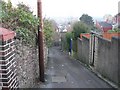
6
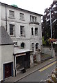
Former barbers in Stow Hill Newport
In July 2014, the single storey building showing GENTS HAIRDRESSERS,
near the corner of Vicarage Hill, had been disused for some time.
A jumble of junk can be seen through the window.
Image: © Jaggery
Taken: 18 Jul 2014
0.04 miles
7
Park Square Day Services, Newport
Located at 12 Park Square, the premises provide some outpatient services for the Aneurin Bevan Health Board, which is responsible for the delivery of health care services to more than 600,000 people living in Newport, Blaenau Gwent, Caerphilly, Monmouthshire and Torfaen.
The Health Board came into being on October 1st 2009. It replaced the former Gwent Healthcare NHS Trust and various other Local Health Boards in the area.
Image: © Jaggery
Taken: 16 Nov 2009
0.04 miles
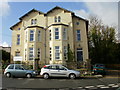
8
Welcome Finance, Newport
Premises at 11 Park Square. Grade II listed, Cadw reference 3032. Cadw is part of the Welsh Assembly Government, with the mission to protect, conserve and promote the built heritage of Wales. It is the Welsh equivalent of English Heritage and Historic Scotland.
Image: © Jaggery
Taken: 16 Nov 2009
0.04 miles
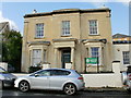
9
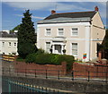
Listed building : 81 Stow Hill, Newport
Grade II listed early 19th century Greek villa with Doric portico.
Image: © Jaggery
Taken: 30 May 2010
0.04 miles
10
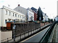
Newport : Stow Hill houses south of Victoria Place
Houses on the east side of Stow Hill, viewed from the elevated pavement opposite Victoria Place. http://www.geograph.org.uk/photo/1911906
Image: © Jaggery
Taken: 6 Mar 2011
0.04 miles