IMAGES TAKEN NEAR TO
St. Marys Court, NEWPORT, NP20 4DP
Introduction
This page details the photographs taken nearby to St. Marys Court, NP20 4DP by members of the Geograph project.
The Geograph project started in 2005 with the aim of publishing, organising and preserving representative images for every square kilometre of Great Britain, Ireland and the Isle of Man.

There are currently over 7.5m images from over14,400 individuals and you can help contribute to the project by visiting https://www.geograph.org.uk
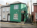
Image Map
Images are licensed for reuse under creativecommons.org/licenses/by-sa/2.0
Notes
- Clicking on the map will re-center to the selected point.
- The higher the marker number, the further away the image location is from the centre of the postcode.
Image Listing (2488 Images Found)
Images are licensed for reuse under creativecommons.org/licenses/by-sa/2.0
Image
Details
Distance
1
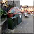
Havelock Street telecoms cabinets, Baneswell, Newport
Near the mural http://www.geograph.org.uk/photo/1585120 on the corner of North Street.
Image: © Jaggery
Taken: 23 Feb 2018
0.02 miles
2
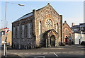
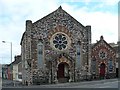
Havelock Street Presbyterian Church of Wales chapel, Baneswell, Newport
The chapel on the corner of North Street and Havelock Street is the 1878 rebuild, in a medieval style derived from North Italian examples, of the 1864 original. The adjacent hall in Havelock Street was added c1888.
The chapel and hall were jointly Grade II listed in 1997 as good examples of the polychromatic Italianate style.
Image: © Jaggery
Taken: 23 Feb 2018
0.02 miles
3
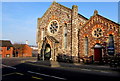
Grade II listed chapel and hall, Havelock Street, Baneswell, Newport
Havelock Street Presbyterian Church of Wales chapel in the centre of the photo is the 1878 rebuild, in a medieval style derived from North Italian examples, of the 1864 original. The adjacent hall was added c1888. The chapel and hall were jointly Grade II listed in 1997 as good examples of the polychromatic Italianate style.
Image: © Jaggery
Taken: 23 Feb 2018
0.03 miles
4

Night Lodge hotel name sign, Newport
Alongside the entrance to the hotel's car park. http://www.geograph.org.uk/photo/4749564
Image: © Jaggery
Taken: 21 Nov 2015
0.03 miles
5
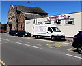
Baneswell Club premises and van, Newport
Social club viewed across Havelock Street from the corner of Stow Hill.
Image: © Jaggery
Taken: 22 Jun 2018
0.03 miles
6
The Londoner, Baneswell, Newport
Formerly O'Reilly's. Located on the corner of North Street and a lane, Wesley Place, which leads to Stow Hill.
Image: © Jaggery
Taken: 16 Nov 2009
0.03 miles
7
Central Surgery, Newport
This is the entrance to the surgery, from Scard Street, Baneswell. The surgery has three doctors.
Image: © Jaggery
Taken: 4 Apr 2010
0.03 miles
8
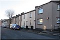
St Mary Street, Baneswell, Newport
The houses are on the south side of the street. The corner of St Woolos Road is on the right.
Image: © Jaggery
Taken: 21 Nov 2015
0.03 miles
9
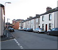
Eastern end of St Mary Street, Baneswell, Newport
From the corner of Beaufort Terrace in the Baneswell area of Newport.
Image: © Jaggery
Taken: 21 Nov 2015
0.03 miles
10
Havelock Street Presbyterian Church
This Grade II listed Church was built in 1863 and is a typical example of the polychromatic Italianate style of architecture.
Image: © Robin Drayton
Taken: 25 Apr 2009
0.03 miles