IMAGES TAKEN NEAR TO
Beaufort Terrace, NEWPORT, NP20 4DH
Introduction
This page details the photographs taken nearby to Beaufort Terrace, NP20 4DH by members of the Geograph project.
The Geograph project started in 2005 with the aim of publishing, organising and preserving representative images for every square kilometre of Great Britain, Ireland and the Isle of Man.

There are currently over 7.5m images from over14,400 individuals and you can help contribute to the project by visiting https://www.geograph.org.uk
Image Map
Images are licensed for reuse under creativecommons.org/licenses/by-sa/2.0
Notes
- Clicking on the map will re-center to the selected point.
- The higher the marker number, the further away the image location is from the centre of the postcode.
Image Listing (2141 Images Found)
Images are licensed for reuse under creativecommons.org/licenses/by-sa/2.0
Image
Details
Distance
1
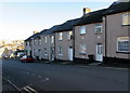
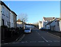
Down Beaufort Terrace, Baneswell, Newport
Beaufort Terrace is a row of houses extending for 30 metres from St Mary Street to West Street.
Image: © Jaggery
Taken: 21 Nov 2015
0.01 miles
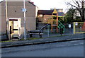
2

Warning sign - playground ahead, Baneswell, Newport
The bilingual (English/Welsh) sign is on the approach to this http://www.geograph.org.uk/photo/4748657 yellow entrance gate to a playground.
Image: © Jaggery
Taken: 21 Nov 2015
0.01 miles
3
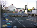
Children's playground in Baneswell, Newport
On the corner of Victoria Crescent (this side) and West Street.
A nearby notice http://www.geograph.org.uk/photo/4748628 states that the playground is for children aged 3-9.
Image: © Jaggery
Taken: 21 Nov 2015
0.01 miles
4
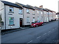
Beaufort Terrace, Baneswell, Newport
Row of houses extending for 30 metres from West Street (behind the camera) to St Mary Street.
Image: © Jaggery
Taken: 21 Nov 2015
0.01 miles
5
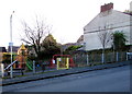
Yellow gate entrance to Baneswell playground, Newport
West Street entrance to the playground on the corner of Victoria Crescent.
Notices facing the entrance show No Dogs and No Smoking.
Image: © Jaggery
Taken: 21 Nov 2015
0.02 miles
6
West Street phonebox, Baneswell, Newport
Grey BT phonebox on the corner of Victoria Crescent, at the edge of a playground.
Image: © Jaggery
Taken: 21 Nov 2015
0.02 miles
7
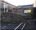
Wall at the southern end of Bailey Street, Baneswell, Newport
The perimeter wall of a St Mary Street building is at the top end of Bailey Street.
Image: © Jaggery
Taken: 21 Nov 2015
0.02 miles
8
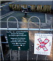
Where we play, please stay away, Baneswell, Newport
Depicting a large red X crossing out a lit cigarette,
the notice is at the Victoria Crescent entrance to this http://www.geograph.org.uk/photo/4748627 playground.
The Newport City Council notice states that the playground is for children aged 3-9.
Image: © Jaggery
Taken: 21 Nov 2015
0.02 miles
9
Warning sign - two way traffic ahead, Baneswell, Newport
The sign is on the corner of West Street (ahead) and Victoria Crescent.
Image: © Jaggery
Taken: 21 Nov 2015
0.03 miles
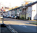
10
Victoria Crescent, Baneswell, Newport
Looking westwards from Bailey Street towards West Street.
The longer (and crescent-shaped) part of Victoria Crescent is on the far side of West Street.
Image: © Jaggery
Taken: 21 Nov 2015
0.03 miles