IMAGES TAKEN NEAR TO
St. Mary Street, NEWPORT, NP20 4DG
Introduction
This page details the photographs taken nearby to St. Mary Street, NP20 4DG by members of the Geograph project.
The Geograph project started in 2005 with the aim of publishing, organising and preserving representative images for every square kilometre of Great Britain, Ireland and the Isle of Man.

There are currently over 7.5m images from over14,400 individuals and you can help contribute to the project by visiting https://www.geograph.org.uk
Image Map
Images are licensed for reuse under creativecommons.org/licenses/by-sa/2.0
Notes
- Clicking on the map will re-center to the selected point.
- The higher the marker number, the further away the image location is from the centre of the postcode.
Image Listing (1932 Images Found)
Images are licensed for reuse under creativecommons.org/licenses/by-sa/2.0
Image
Details
Distance
1
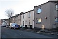
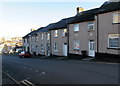
St Mary Street, Baneswell, Newport
The houses are on the south side of the street. The corner of St Woolos Road is on the right.
Image: © Jaggery
Taken: 21 Nov 2015
0.02 miles
2
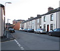
Eastern end of St Mary Street, Baneswell, Newport
From the corner of Beaufort Terrace in the Baneswell area of Newport.
Image: © Jaggery
Taken: 21 Nov 2015
0.02 miles
3
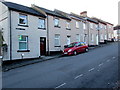
Beaufort Terrace, Baneswell, Newport
Row of houses extending for 30 metres from West Street (behind the camera) to St Mary Street.
Image: © Jaggery
Taken: 21 Nov 2015
0.02 miles
4
Jones Street, Baneswell
The rear of Image can just be seen at the far end of the street.
Image: © Robin Drayton
Taken: 4 Mar 2008
0.03 miles
5

Warning sign - playground ahead, Baneswell, Newport
The bilingual (English/Welsh) sign is on the approach to this http://www.geograph.org.uk/photo/4748657 yellow entrance gate to a playground.
Image: © Jaggery
Taken: 21 Nov 2015
0.03 miles
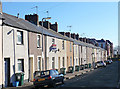
6
Down Beaufort Terrace, Baneswell, Newport
Beaufort Terrace is a row of houses extending for 30 metres from St Mary Street to West Street.
Image: © Jaggery
Taken: 21 Nov 2015
0.03 miles
7
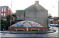
Baneswell mural, Newport
On the corner of North Street and Havelock Street, this mural was designed by the children of St Woolos Primary School. http://www.geograph.org.uk/photo/1585130 Part of the school building can be seen in the upper left of the photo.
The mural depicts various well-known Newport locations, including St Woolos Cathedral and the Transporter Bridge.
Image: © Jaggery
Taken: 16 Nov 2009
0.03 miles
8
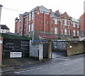
St Woolos Primary School, Stow Hill, Newport
View of the school from North Street. The school opened in 1904.
Image: © Jaggery
Taken: 16 Nov 2009
0.03 miles
9
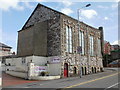
Side view of Havelock Street Presbyterian Church, Newport
Viewed from North Street. http://www.geograph.org.uk/photo/1271562 to a view of the Grade II listing building from Havelock Street.
Image: © Jaggery
Taken: 4 Apr 2010
0.03 miles
10
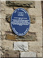
Blue plaque, Havelock Street Presbyterian Church, Newport
The blue plaque, on the North Street side http://www.geograph.org.uk/photo/1792980 of the building, records the founding of the Boys' Brigade in Wales at the church in 1887. The plaque also records the 1997 Grade II listing for the church.
Image: © Jaggery
Taken: 4 Apr 2010
0.03 miles