IMAGES TAKEN NEAR TO
West Street, NEWPORT, NP20 4DD
Introduction
This page details the photographs taken nearby to West Street, NP20 4DD by members of the Geograph project.
The Geograph project started in 2005 with the aim of publishing, organising and preserving representative images for every square kilometre of Great Britain, Ireland and the Isle of Man.

There are currently over 7.5m images from over14,400 individuals and you can help contribute to the project by visiting https://www.geograph.org.uk
Image Map
Images are licensed for reuse under creativecommons.org/licenses/by-sa/2.0
Notes
- Clicking on the map will re-center to the selected point.
- The higher the marker number, the further away the image location is from the centre of the postcode.
Image Listing (2624 Images Found)
Images are licensed for reuse under creativecommons.org/licenses/by-sa/2.0
Image
Details
Distance
1
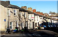
West side of West Street, Baneswell, Newport
Descending northwards toward the city centre from the corner of Victoria Crescent.
Image: © Jaggery
Taken: 21 Nov 2015
0.00 miles
2
Into Baneswell, central Newport
From Bridge Street down Caxton Place across Baneswell Road up West Street in the Baneswell area of Newport.
Image: © Jaggery
Taken: 13 Jun 2018
0.02 miles
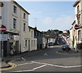
3
West Street, Newport
Viewed from opposite the Age Concern office http://www.geograph.org.uk/photo/3430102 in the Baneswell area of Newport.
West Street ascends from Baneswell Road towards Victoria Crescent.
Image: © Jaggery
Taken: 5 Mar 2013
0.02 miles
4
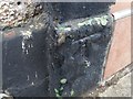
Ordnance Survey Cut Mark
This OS cut mark can be found on No17 West Street. It marks a point 22.825m above mean sea level.
Image: © Adrian Dust
Taken: 17 Jun 2018
0.02 miles
5
NSPCC, Baneswell, Newport
NSPCC (National Society for the Prevention of Cruelty to Children) premises at 2 Bailey Street, Baneswell, on the corner of Pump Street.
Image: © Jaggery
Taken: 14 Feb 2010
0.02 miles
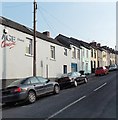
6
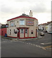
The Angel, Baneswell, Newport
Pub on the corner of West Street and Blewitt Street, Baneswell.
UPDATE DECEMBER 2012.
The pub is now The Angel Lounge, a cocktail & wine bar. http://www.geograph.org.uk/photo/3276032
Image: © Jaggery
Taken: 14 Feb 2010
0.02 miles
7
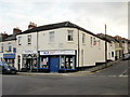
Age Concern offices, Baneswell, Newport
Located on the corner of West Street and Baneswell Road.
Image: © Jaggery
Taken: 14 Feb 2010
0.02 miles
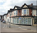
8
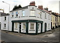
Queens Chambers, Newport
Viewed from the corner of Pump Street and Bailey Street, Baneswell. Queens Chambers are the premises of Harding Evans, a law firm. There is a blue plaque http://www.geograph.org.uk/photo/1792966 on the rounded part of the building, referring to its 19th century name, The Friars.
Image: © Jaggery
Taken: 4 Apr 2010
0.02 miles
9
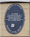
Blue plaque, Queens Chambers, Newport
The Newport Civic Society's plaque records that in the 19th century, the building, then known as The Friars, was the home of antiquarian and horologist Octavius Morgan (1803-1888). The building is now Queens Chambers. http://www.geograph.org.uk/photo/1792965
Image: © Jaggery
Taken: 4 Apr 2010
0.02 miles
10
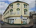
Offices of HPJV, Newport
Offices at 14 Baneswell Road.
HPJV (Hodson, Parsons, James & Vaux ) was formed in 1999 by the amalgamation of two of Newport's firms of solicitors - Hodson, Parsons from west of the river Usk and Derek James & Vaux from the east.
Image: © Jaggery
Taken: 4 Apr 2010
0.02 miles