IMAGES TAKEN NEAR TO
Montreal Close, NEWPORT, NP20 3RD
Introduction
This page details the photographs taken nearby to Montreal Close, NP20 3RD by members of the Geograph project.
The Geograph project started in 2005 with the aim of publishing, organising and preserving representative images for every square kilometre of Great Britain, Ireland and the Isle of Man.

There are currently over 7.5m images from over14,400 individuals and you can help contribute to the project by visiting https://www.geograph.org.uk
Image Map
Images are licensed for reuse under creativecommons.org/licenses/by-sa/2.0
Notes
- Clicking on the map will re-center to the selected point.
- The higher the marker number, the further away the image location is from the centre of the postcode.
Image Listing (130 Images Found)
Images are licensed for reuse under creativecommons.org/licenses/by-sa/2.0
Image
Details
Distance
1
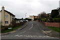
Montreal Close, Newport
Cul-de-sac on the northwest side of Melbourne Way.
Image: © Jaggery
Taken: 17 Mar 2017
0.02 miles
2
New Road Layout Ahead sign, Melbourne Way, Newport
The bilingual (English/Welsh) red sign faces Melbourne Way on the approach to Glasllwch Primary School.
Image: © Jaggery
Taken: 17 Mar 2017
0.03 miles
3
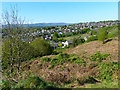
Looking towards the north from Gaer Fort
The Glasllwch area of Newport is in the middle distance.
Mynydd Henllys https://www.geograph.org.uk/gridref/ST2594 is on the horizon.
Image: © Robin Drayton
Taken: 20 Apr 2020
0.03 miles
4
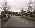
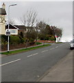
Tree-lined Melbourne Way, Newport
Melbourne Way descends towards Western Avenue past the Montreal Close junction http://www.geograph.org.uk/photo/5315400 on the right.
Image: © Jaggery
Taken: 17 Mar 2017
0.03 miles
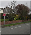
5
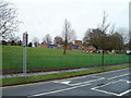
Your Speed indicator facing Melbourne Way, Newport
Apparently showing 188, but actually off at the moment. When a vehicle approaches, the indicator is illuminated to display its speed, in green numbers if within the speed limit, in red numbers if higher.
Image: © Jaggery
Taken: 17 Mar 2017
0.03 miles
6
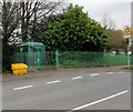
Melbourne Way electricity substation , Newport
The dark green cabinet is a Western Power Distribution electricity substation, identifier S/S 53-1240, located at the edge of Glasllwch Primary School.
Image: © Jaggery
Taken: 17 Mar 2017
0.04 miles
7
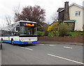
R3 bus ascends Melbourne Way, Newport
The NAT (New Adventure Travel) bus is on route R3 to Market Square bus station in Newport city centre.
Image: © Jaggery
Taken: 17 Mar 2017
0.04 miles
8
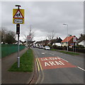
Warning sign - Patrol, Melbourne Way, Newport
On the approach to Glasllwch Primary School.
At speed bumps ahead, the 30mph speed limit drops to 20mph.
Image: © Jaggery
Taken: 17 Mar 2017
0.04 miles
9
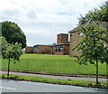
Glasllwch Primary School, Newport
Much of the perimeter of the school is tree-lined. This view is through a narrow gap in the trees, looking at the SE side of the school, from Melbourne Way.
Image: © Jaggery
Taken: 25 Jul 2010
0.04 miles
10
Glasllwch Primary School, Newport
The western side of the school viewed across Melbourne Way.
Image: © Jaggery
Taken: 18 Nov 2010
0.04 miles