IMAGES TAKEN NEAR TO
Western Avenue, NEWPORT, NP20 3QX
Introduction
This page details the photographs taken nearby to Western Avenue, NP20 3QX by members of the Geograph project.
The Geograph project started in 2005 with the aim of publishing, organising and preserving representative images for every square kilometre of Great Britain, Ireland and the Isle of Man.

There are currently over 7.5m images from over14,400 individuals and you can help contribute to the project by visiting https://www.geograph.org.uk
Image Map
Images are licensed for reuse under creativecommons.org/licenses/by-sa/2.0
Notes
- Clicking on the map will re-center to the selected point.
- The higher the marker number, the further away the image location is from the centre of the postcode.
Image Listing (117 Images Found)
Images are licensed for reuse under creativecommons.org/licenses/by-sa/2.0
Image
Details
Distance
1
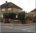
Corner of Western Avenue and Vancouver Drive, Newport
Viewed across Western Avenue. A red drop box is between telecoms cabinets.
Image: © Jaggery
Taken: 17 Mar 2017
0.01 miles
2
Western Avenue bus stop, Newport
On the east side of Western Avenue, between the Vancouver Drive junction and the Melbourne Way junction.
In March 2017, this stop is on bus route R3 from Morrisons in Rogerstone to Market Square bus station Newport.
Image: © Jaggery
Taken: 17 Mar 2017
0.02 miles
3
Corner of Western Avenue and Vancouver Drive, Newport
Viewed across Western Avenue.
Vancouver Drive on the right extends for nearly 600 metres, ending at the Canberra Crescent junction.
Image: © Jaggery
Taken: 29 Sep 2012
0.02 miles
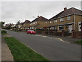
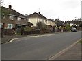
4
Western Avenue houses, Newport
Houses on the west side of Western Avenue between Vancouver Drive and Melbourne Way (ahead).
Image: © Jaggery
Taken: 29 Sep 2012
0.02 miles
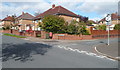
5
Western Avenue bus stop, Newport
On the west side of Western Avenue, between the Vancouver Drive junction and the Melbourne Way junction.
In March 2017, this stop is on bus route R3 from Market Square bus station Newport to Morrisons in Rogerstone.
Image: © Jaggery
Taken: 17 Mar 2017
0.04 miles
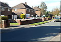
6
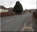
North along Western Avenue, Newport
Western Avenue extends for nearly 800 metres from Bassaleg Road (behind the camera) to the B4591.
Image: © Jaggery
Taken: 17 Mar 2017
0.05 miles
7
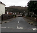
Auckland Road, Newport
Auckland Road descends from Melbourne Way to Vancouver Drive.
Image: © Jaggery
Taken: 17 Mar 2017
0.07 miles
8
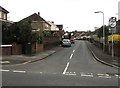
Vancouver Drive, Newport
Vancouver Drive ascends from Western Avenue. A dark green telecoms cabinet is on the left.
Image: © Jaggery
Taken: 17 Mar 2017
0.07 miles
9
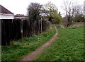
Path alongside Nant Coch, Newport
Viewed from the edge of Western Avenue. The path ahead is alongside a stream, Nant Coch. The signs show Sirhowy Valley Walk. The name is somewhat confusing, because Newport is several miles from the Sirhowy, which flows into the Ebbw at Crosskeys. http://www.geograph.org.uk/photo/2351055
Image: © Jaggery
Taken: 29 Sep 2012
0.07 miles
10
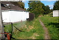
Track on a bank of Nant Coch, Newport
From this http://www.geograph.org.uk/photo/5315033 kissing gate, a track heads NE away from Western Avenue.
The brook named Nant Coch is behind the fence.
Image: © Jaggery
Taken: 17 Mar 2017
0.07 miles