IMAGES TAKEN NEAR TO
Vancouver Drive, NEWPORT, NP20 3QT
Introduction
This page details the photographs taken nearby to Vancouver Drive, NP20 3QT by members of the Geograph project.
The Geograph project started in 2005 with the aim of publishing, organising and preserving representative images for every square kilometre of Great Britain, Ireland and the Isle of Man.

There are currently over 7.5m images from over14,400 individuals and you can help contribute to the project by visiting https://www.geograph.org.uk
Image Map
Images are licensed for reuse under creativecommons.org/licenses/by-sa/2.0
Notes
- Clicking on the map will re-center to the selected point.
- The higher the marker number, the further away the image location is from the centre of the postcode.
Image Listing (125 Images Found)
Images are licensed for reuse under creativecommons.org/licenses/by-sa/2.0
Image
Details
Distance
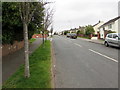
1
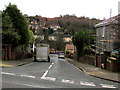
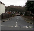
Wellington Road, Newport
Wellington Road descends from Melbourne Way to Vancouver Drive.
Image: © Jaggery
Taken: 17 Mar 2017
0.01 miles
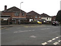
2
A western section of Vancouver Drive, Newport
Viewed from opposite the Auckland Road junction http://www.geograph.org.uk/photo/3154353
looking towards the junction with Wellington Road. http://www.geograph.org.uk/photo/3154395
Image: © Jaggery
Taken: 29 Sep 2012
0.01 miles
3
Western end of Vancouver Drive, Newport
Viewed across Western Avenue.
Vancouver Drive extends for nearly 600 metres ahead, ending at the Canberra Crescent junction.
Image: © Jaggery
Taken: 29 Sep 2012
0.03 miles
4
Wellington Road, Newport
Viewed across Melbourne Way looking in the direction of Vancouver Drive.
Image: © Jaggery
Taken: 18 Nov 2010
0.03 miles
5
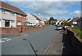
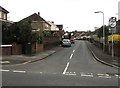
Auckland Road, Newport
Auckland Road descends from Melbourne Way to Vancouver Drive.
Image: © Jaggery
Taken: 17 Mar 2017
0.05 miles
6
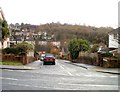
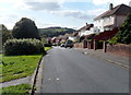
Vancouver Drive, Newport
Vancouver Drive ascends from Western Avenue. A dark green telecoms cabinet is on the left.
Image: © Jaggery
Taken: 17 Mar 2017
0.05 miles
7
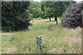
Sirhowy Valley Walk path above Nant Coch
Grass footpath through linear nature conservation area below Vancouver Drive. The Newport Council bilingual sign says, 'Nature Conservation Area'.
Image: © M J Roscoe
Taken: 10 Jul 2017
0.05 miles
8
A view down Vancouver Drive, Newport
Viewed from the edge of a path http://www.geograph.org.uk/photo/3154760 to a recreation area and nature reserve.
Image: © Jaggery
Taken: 29 Sep 2012
0.05 miles
9
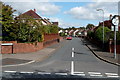
Melbourne Way bus stop, Newport
Opposite Quebec Close. http://www.geograph.org.uk/photo/5315368
Image: © Jaggery
Taken: 17 Mar 2017
0.08 miles
10
Up Melbourne Way, Newport
Melbourne Way ascends towards the Toronto Close junction. http://www.geograph.org.uk/photo/5315395
Image: © Jaggery
Taken: 17 Mar 2017
0.08 miles