IMAGES TAKEN NEAR TO
Glasllwch Lane, NEWPORT, NP20 3PU
Introduction
This page details the photographs taken nearby to Glasllwch Lane, NP20 3PU by members of the Geograph project.
The Geograph project started in 2005 with the aim of publishing, organising and preserving representative images for every square kilometre of Great Britain, Ireland and the Isle of Man.

There are currently over 7.5m images from over14,400 individuals and you can help contribute to the project by visiting https://www.geograph.org.uk
Image Map
Images are licensed for reuse under creativecommons.org/licenses/by-sa/2.0
Notes
- Clicking on the map will re-center to the selected point.
- The higher the marker number, the further away the image location is from the centre of the postcode.
Image Listing (108 Images Found)
Images are licensed for reuse under creativecommons.org/licenses/by-sa/2.0
Image
Details
Distance
1
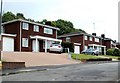
Glasllwch View, Newport
Houses at the northern end of Glasllwch View, a cul-de-sac of 38 houses built c1990.
Viewed from the edge of Trinity Methodist Church. http://www.geograph.org.uk/photo/2528959
Image: © Jaggery
Taken: 21 Jul 2011
0.01 miles
2
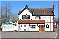
The Three Murghals
Indian Restaurant, Pye Corner near Newport.
Image: © Wayland Smith
Taken: 13 Apr 2014
0.04 miles
3
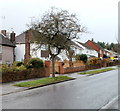
Western side of Western Avenue, Newport
Western Avenue houses viewed from the corner of Melbourne Way.
Image: © Jaggery
Taken: 18 Nov 2010
0.06 miles
4
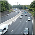
M4 motorway viewed from Bassaleg Road, Newport
Looking north in the direction of junction 27, from Bassaleg Road bridge. http://www.geograph.org.uk/photo/2079396
Image: © Jaggery
Taken: 21 Jul 2011
0.06 miles
5
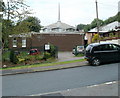
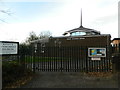
Trinity Methodist Church, Newport
Located on Glasllwch Lane, facing Glasllwch View. http://www.geograph.org.uk/photo/2528973
The church was built in 1970.
Image: © Jaggery
Taken: 21 Jul 2011
0.06 miles
6
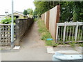
Path from Glasllwch Lane to Parklands Close, Newport
A short path runs along the western edge of the M4 motorway. On the right is the edge of the bridge carrying Glasllwch Lane above the motorway.
Image: © Jaggery
Taken: 21 Jul 2011
0.06 miles
7
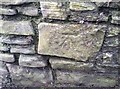
Ordnance Survey Cut Mark
This OS cut mark can be found on the wall at the junction of Bassaleg Road & Glasllwch Lane. It marks a point 33.107m above mean sea level.
Image: © Adrian Dust
Taken: 29 Dec 2019
0.07 miles
8
Trinity Methodist Church, Glasllwch, Newport
Image: © John Lord
Taken: 22 Nov 2014
0.07 miles
9
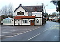
The Three Mughals, Rogerstone, Newport
Restaurant serving contemporary Indian cuisine, located at 7 Western Valley Road, Pye Corner, Rogerstone. The building was formerly The Three Salmons pub.
The Three Mughals was officially opened on February 20th 2008 by His Excellency Khondaker Mostan Hossain, the High Commissioner of Bangladesh, and Councillor Debbie Wilcox, the Deputy Mayor of Newport.
Image: © Jaggery
Taken: 17 Jan 2011
0.07 miles
10
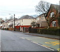
Western Valley Road houses, Rogerstone, Newport
Viewed from the edge of The Three Mughals.http://www.geograph.org.uk/photo/2236080
Image: © Jaggery
Taken: 17 Jan 2011
0.07 miles