IMAGES TAKEN NEAR TO
Glasllwch Lane, NEWPORT, NP20 3PR
Introduction
This page details the photographs taken nearby to Glasllwch Lane, NP20 3PR by members of the Geograph project.
The Geograph project started in 2005 with the aim of publishing, organising and preserving representative images for every square kilometre of Great Britain, Ireland and the Isle of Man.

There are currently over 7.5m images from over14,400 individuals and you can help contribute to the project by visiting https://www.geograph.org.uk
Image Map
Images are licensed for reuse under creativecommons.org/licenses/by-sa/2.0
Notes
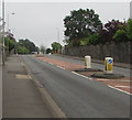
- Clicking on the map will re-center to the selected point.
- The higher the marker number, the further away the image location is from the centre of the postcode.
Image Listing (102 Images Found)
Images are licensed for reuse under creativecommons.org/licenses/by-sa/2.0
Image
Details
Distance
1
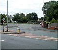
Ridgeway crossroads, Newport
The SW end of Ridgeway reaches the B4591, which to the left is named Risca Road and to the right, past the red phone box, Glasllwch Crescent. Ahead is Melbourne Way, leading to Western Avenue.
Image: © Jaggery
Taken: 25 Jul 2010
0.03 miles
2
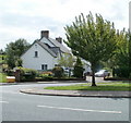
Glasllwch Lane, Newport
The house is at the eastern end of Glasllwch Lane, viewed across Melbourne Way.
The far end of the Lane connects with Western Avenue, then crosses above the M4 motorway, and ends at Bassaleg Road.
Image: © Jaggery
Taken: 25 Jul 2010
0.03 miles
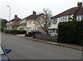
3
Melbourne Way houses, Newport
Houses on the west side of the road, between Glasllwch Crescent and the northern arm of Canberra Crescent.
Image: © Jaggery
Taken: 25 Jul 2010
0.04 miles
4
Glasllwch Crescent, Newport
The B4591 has various names in this area of Newport. Behind the camera, it is Risca Road. Ahead, it is Glasllwch Crescent, then High Cross Road, Cefn Road, and finally Risca Road again, near the western edge of Newport.
Image: © Jaggery
Taken: 25 Jul 2010
0.05 miles
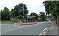
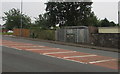
5
Pedestrian refuge in the B4591 Glasllwch Crescent, Newport
Between Keep Left signs. Two similar refuges are in the background.
Image: © Jaggery
Taken: 26 Jun 2019
0.05 miles
6
Glasllwch Crescent semis, Newport
Semi-detached houses on the south side of the B4591 Glasllwch Crescent.
Image: © Jaggery
Taken: 26 Jun 2019
0.05 miles
7
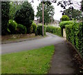
Bend in Glasllwch Lane, Newport
From Melbourne Way, Glasllwch Lane leads to Western Avenue.
Image: © Jaggery
Taken: 26 Jun 2019
0.05 miles
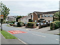
8
Glasllwch electricity substation, Newport
The Western Power Distribution electricity substation is on the south side
of the B4591 Glasllwch Crescent. Its identifier is GLASLLWCH NEWPORT S/S 531241
Image: © Jaggery
Taken: 26 Jun 2019
0.06 miles
9
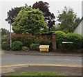
Yellow salt/grit box, Glasllwch Lane, Newport
Near the corner of Melbourne Way, behind the tree here. https://www.geograph.org.uk/photo/6193439
Image: © Jaggery
Taken: 26 Jun 2019
0.06 miles
10
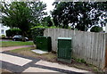
Dark green cabinets on a Glasllwch corner, Newport
Telecoms cabinets on the corner of Glasllwch Crescent and Melbourne Way in the Glasllwch area of Newport.
Image: © Jaggery
Taken: 26 Jun 2019
0.07 miles