IMAGES TAKEN NEAR TO
Gaer Park Avenue, NEWPORT, NP20 3NW
Introduction
This page details the photographs taken nearby to Gaer Park Avenue, NP20 3NW by members of the Geograph project.
The Geograph project started in 2005 with the aim of publishing, organising and preserving representative images for every square kilometre of Great Britain, Ireland and the Isle of Man.

There are currently over 7.5m images from over14,400 individuals and you can help contribute to the project by visiting https://www.geograph.org.uk
Image Map
Images are licensed for reuse under creativecommons.org/licenses/by-sa/2.0
Notes
- Clicking on the map will re-center to the selected point.
- The higher the marker number, the further away the image location is from the centre of the postcode.
Image Listing (175 Images Found)
Images are licensed for reuse under creativecommons.org/licenses/by-sa/2.0
Image
Details
Distance
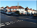
1
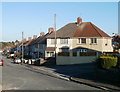
Corner of Gaer Park Parade and Gaer Park Avenue, Newport
The Gaer Park area of Newport is a 1930s housing development.
Image: © Jaggery
Taken: 10 Nov 2010
0.03 miles
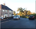
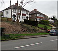
2
Top end of Castle Park Road, Newport
Houses viewed along the steep climb up Castle Park Road from Castle Park Close.
Image: © Jaggery
Taken: 10 Nov 2010
0.07 miles
3
Gaer Park Lane, Newport
Houses on the west side of Gaer Park Lane, viewed from the corner of Gaer Park Parade.
Image: © Jaggery
Taken: 10 Nov 2010
0.07 miles
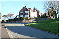
4
Castle Park Road houses with a fine view, Newport
Houses at the top end of Castle Park Road have contrasting views from opposite sides of the house.
From the camera side of the houses, the view is of houses on Gaer Park Parade. From the opposite side, the view is of undulating ridges of high ground to the NW.
Image: © Jaggery
Taken: 10 Nov 2010
0.07 miles
5
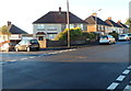
Southern corner of Gaer Park Road and Gaer Park Parade, Newport
Vehicles on Gaer Park Road here have priority over vehicles in Gaer Park Parade.
The broken white lines are at the edges of Gaer Park Parade.
Image: © Jaggery
Taken: 6 Oct 2012
0.08 miles
6
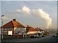
Gaer Park Parade and man made cumulus clouds
With calm conditions and high humidity, cumulus clouds form in the convection from ImageThis one of the cleanest coal-fired power stations in the UK and also uses biomass for electricity generation. http://www.uskmouthpower.com/index.php?page=about-uskmouth
Image: © Robin Drayton
Taken: 28 Nov 2008
0.09 miles
7
201 Bassaleg Road, Newport
Most houses have a small plate or similar near the front door to indicate the house number.
Here, the number 201 is displayed in a large panel at upper floor level on the house on the right.
Image: © Jaggery
Taken: 29 Sep 2012
0.10 miles
8
SW end of Gaer Park Road, Newport
About 420 metres SW of its other end at the Gaer Park Drive junction, Gaer Park Road ends
at the edge of an open space known as Gaer Fort or Tredegar Fort. http://www.geograph.org.uk/photo/619433
Image: © Jaggery
Taken: 6 Oct 2012
0.10 miles
9
Northern corner of Gaer Park Drive and Gaer Park Parade, Newport
Viewed from Gaer Park Parade looking across Gaer Park Drive.
Image: © Jaggery
Taken: 6 Oct 2012
0.10 miles
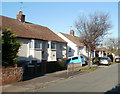
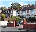
10
Houses above Bassaleg Road, Newport
On the south side of the road, north of the Gaer area of Newport.
Image: © Jaggery
Taken: 17 Mar 2017
0.10 miles