IMAGES TAKEN NEAR TO
Wells Close, NEWPORT, NP20 3LJ
Introduction
This page details the photographs taken nearby to Wells Close, NP20 3LJ by members of the Geograph project.
The Geograph project started in 2005 with the aim of publishing, organising and preserving representative images for every square kilometre of Great Britain, Ireland and the Isle of Man.

There are currently over 7.5m images from over14,400 individuals and you can help contribute to the project by visiting https://www.geograph.org.uk
Image Map
Images are licensed for reuse under creativecommons.org/licenses/by-sa/2.0
Notes
- Clicking on the map will re-center to the selected point.
- The higher the marker number, the further away the image location is from the centre of the postcode.
Image Listing (181 Images Found)
Images are licensed for reuse under creativecommons.org/licenses/by-sa/2.0
Image
Details
Distance
1
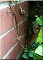
Ordnance Survey Cut Mark
This OS cut mark can be found on the wall of No3 Wells Close. It marks a point 27.760m above mean sea level.
Image: © Adrian Dust
Taken: 2 Aug 2021
0.02 miles
2
Marryat Walk, Gaer, Newport
There are no houses on Marryat Walk. It is a very short road connecting Shakespeare Crescent with the footbridge across the railway lines at Park Junction. http://www.geograph.org.uk/photo/1579956
Image: © Jaggery
Taken: 12 Nov 2009
0.02 miles
3
Walking the dogs near Wells Close, Newport
After walking their dogs in Gaer Fort open space, two woman are heading for Wells Close.
Image: © Jaggery
Taken: 19 Jul 2011
0.03 miles
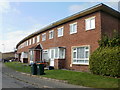
4
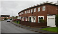
Wells Close, Gaer, Newport
The view from Shakespeare Crescent of houses on the north side of Wells Close.
Image: © Jaggery
Taken: 12 Nov 2009
0.04 miles
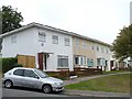
5
Hardy Close, Gaer, Newport
Viewed from Shakespeare Crescent.
Image: © Jaggery
Taken: 12 Feb 2010
0.04 miles
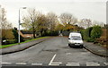
6
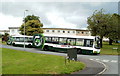
Two buses, Shakespeare Crescent, Newport
Viewed from Wells Close. Ahead, the buses will take different routes back to the central bus station.
One is on Newport Bus route 3, the other is on Newport Bus route 4.
Image: © Jaggery
Taken: 19 Jul 2011
0.04 miles
7
Western side of Wells Close, Gaer, Newport
Viewed from the SE edge of Gaer Fort open space. Wells Close is in the SW corner of the Gaer.
Image: © Jaggery
Taken: 19 Jul 2011
0.04 miles
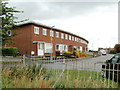
8
Vanbrugh Gardens, Gaer Estate
The Gaer estate was one of the first estates built in Newport after the Second World War. All of the streets are named after writers. A Festival of Britain award was received for the design of the estate and the plaque is displayed on the end house. http://www.geograph.org.uk/photo/621755
Image: © Robin Drayton
Taken: 6 Sep 2007
0.04 miles
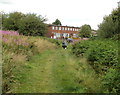
9
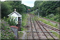
Park Junction, Gaer, Newport
Semaphore signals controlling the Ebbw Valley Railway viewed from a footbridge on the Sirhowy Valley Walk. The signal box appears to be disused.
Image: © M J Roscoe
Taken: 10 Jul 2017
0.04 miles
10
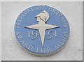
Gaer Estate Award for Merit
http://www.geograph.org.uk/photo/621751
Image: © Robin Drayton
Taken: 6 Sep 2007
0.04 miles