IMAGES TAKEN NEAR TO
Dickens Drive, NEWPORT, NP20 3JL
Introduction
This page details the photographs taken nearby to Dickens Drive, NP20 3JL by members of the Geograph project.
The Geograph project started in 2005 with the aim of publishing, organising and preserving representative images for every square kilometre of Great Britain, Ireland and the Isle of Man.

There are currently over 7.5m images from over14,400 individuals and you can help contribute to the project by visiting https://www.geograph.org.uk
Image Map
Images are licensed for reuse under creativecommons.org/licenses/by-sa/2.0
Notes
- Clicking on the map will re-center to the selected point.
- The higher the marker number, the further away the image location is from the centre of the postcode.
Image Listing (164 Images Found)
Images are licensed for reuse under creativecommons.org/licenses/by-sa/2.0
Image
Details
Distance
1
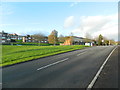
Masefield Vale near the junction with Gaer Rd, Newport
Image: © John Lord
Taken: 22 Nov 2014
0.01 miles
2
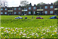
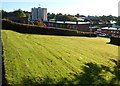
Two storey flats, Dickens Drive, Gaer, Newport
This estate was built on a hilly area on the western edge of Newport. As can be seen in this view, terraces were created to accommodate a number of the roads.
It was one of the first estates built in Newport after the Second World War. All of the streets are named after writers. A Festival of Britain award was received for the design of the estate and a plaque commemorating this is displayed on one of the houses http://www.geograph.org.uk/photo/621751 .
Dandelions and cuckooflowers http://www.geograph.org.uk/photo/5757011 are in the foreground.
The grass here has been left unmown as part of Newport's Bee Friendly initiative.
Image: © Robin Drayton
Taken: 26 Apr 2018
0.01 miles
3
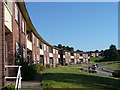
Dickins Drive, Gaer Estate
http://www.geograph.org.uk/photo/621751
Image: © Robin Drayton
Taken: 11 Aug 2007
0.01 miles
5
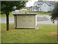
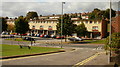
Police building, Gaer Road, Newport
This is the view of the back of the building, showing what appear to have been two windows now bricked over. An earlier photo of the front of the building http://www.geograph.org.uk/photo/636069 shows a similar treatment.
Image: © Jaggery
Taken: 1 Oct 2009
0.02 miles
6
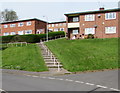
Steps up from Dickens Drive, Gaer, Newport
Ascending towards Ben Jonson Way.
Image: © Jaggery
Taken: 6 May 2016
0.02 miles
7
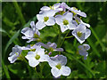
Cuckooflower (Cardamine pratensis), Gaer, Newport
Also known as lady's smock.
See this http://www.geograph.org.uk/photo/5756721 for the surroundings of this specimen.
Image: © Robin Drayton
Taken: 26 Apr 2018
0.04 miles
8
Sloping ground on the south side of Shakespeare Crescent, Newport
A view from Shakespeare Crescent down a slope towards houses in Ben Johnson Way.
Hillview multi-storey block http://www.geograph.org.uk/photo/3166002 is in the background.
Image: © Jaggery
Taken: 6 Oct 2012
0.04 miles
9
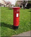
Queen Elizabeth II pillarbox, Dickens Drive, Newport
Located on the right here. http://www.geograph.org.uk/photo/4949022
Image: © Jaggery
Taken: 6 May 2016
0.04 miles
10
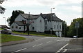
The Gaer Inn, Newport
At 37 Gaer Road. To the right of the inn, Masefield Vale descends towards the lower end of Shakespeare Crescent.
Image: © Jaggery
Taken: 1 Oct 2009
0.04 miles