IMAGES TAKEN NEAR TO
Joyce Close, NEWPORT, NP20 3JD
Introduction
This page details the photographs taken nearby to Joyce Close, NP20 3JD by members of the Geograph project.
The Geograph project started in 2005 with the aim of publishing, organising and preserving representative images for every square kilometre of Great Britain, Ireland and the Isle of Man.

There are currently over 7.5m images from over14,400 individuals and you can help contribute to the project by visiting https://www.geograph.org.uk
Image Map
Images are licensed for reuse under creativecommons.org/licenses/by-sa/2.0
Notes
- Clicking on the map will re-center to the selected point.
- The higher the marker number, the further away the image location is from the centre of the postcode.
Image Listing (115 Images Found)
Images are licensed for reuse under creativecommons.org/licenses/by-sa/2.0
Image
Details
Distance
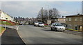
1
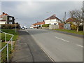
Gaer Park Parade, Newport
Gaer Park Parade climbs away from Shakespeare Crescent.
Image: © Jaggery
Taken: 12 Feb 2010
0.02 miles
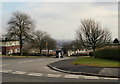
2
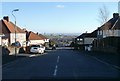
Gaer Park Parade, Newport
Looking past the intersection of Gaer Park Drive towards houses http://www.geograph.org.uk/photo/2153706 at the T junction with Shakespeare Crescent. Beyond, on low ground, is a part of southern Newport.
Image: © Jaggery
Taken: 10 Nov 2010
0.02 miles
3
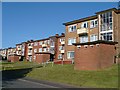
Joyce Close, Newport
Viewed across Gaer Park Parade.
Image: © Jaggery
Taken: 6 Oct 2012
0.02 miles
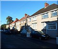
4
Shakespeare Crescent, Gaer Estate
http://www.geograph.org.uk/photo/621751
Image: © Robin Drayton
Taken: 11 Aug 2007
0.03 miles
5
On the eastern edge of Gaer Fort, Newport
Towards the edge of Gaer Estate.
Image: © Robin Drayton
Taken: 28 Aug 2021
0.04 miles
6
Top end of Shakespeare Crescent, Gaer, Newport
Behind the photographer, Shakespeare Crescent has climbed steeply up the Gaer from the corner of Masefield Vale. Ahead is the relatively level section, heading towards Gaer Road. The junction for Gaer Park Parade http://www.geograph.org.uk/photo/1706511 is on the left.
Image: © Jaggery
Taken: 12 Feb 2010
0.05 miles
7
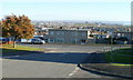
Newport : Shakespeare Crescent houses viewed along Gaer Park Parade
The photographer is in the SW corner of Gaer Park. The houses on Shakespeare Crescent are at the NW corner of the Gaer Estate, where street names are those of famous poets, dramatists and writers.
Image: © Jaggery
Taken: 10 Nov 2010
0.05 miles
8
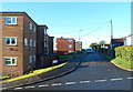
SW end of Gaer Park Drive, Newport
About 650 metres from its other end at the junction with Bassaleg Road, Gaer Park Drive ends at the edge of Gaer Fort open space (ahead), also known as Tredegar Fort. http://www.geograph.org.uk/photo/619433
Image: © Jaggery
Taken: 6 Oct 2012
0.05 miles
9
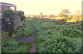
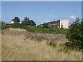
Track along the eastern edge of Gaer Fort open space, Newport
Viewed from the SW end of Gaer Park Drive. The open space is also known as Tredegar Fort. http://www.geograph.org.uk/photo/619433
Image: © Jaggery
Taken: 6 Oct 2012
0.05 miles
10
Trees at the top of Kipling Hill, Gaer, Newport
Viewed from Shakespeare Crescent.
Image: © Jaggery
Taken: 12 Feb 2010
0.06 miles