IMAGES TAKEN NEAR TO
Gaer Road, NEWPORT, NP20 3HZ
Introduction
This page details the photographs taken nearby to Gaer Road, NP20 3HZ by members of the Geograph project.
The Geograph project started in 2005 with the aim of publishing, organising and preserving representative images for every square kilometre of Great Britain, Ireland and the Isle of Man.

There are currently over 7.5m images from over14,400 individuals and you can help contribute to the project by visiting https://www.geograph.org.uk
Image Map
Images are licensed for reuse under creativecommons.org/licenses/by-sa/2.0
Notes
- Clicking on the map will re-center to the selected point.
- The higher the marker number, the further away the image location is from the centre of the postcode.
Image Listing (202 Images Found)
Images are licensed for reuse under creativecommons.org/licenses/by-sa/2.0
Image
Details
Distance
1
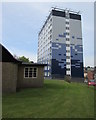
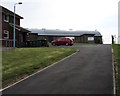
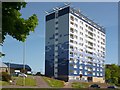
High-rise flats and low-rise church, Gaer, Newport
The 11-storey Hillview flats and the southern edge of St Martin in the Gaer church. https://www.geograph.org.uk/photo/5862250
Image: © Jaggery
Taken: 6 May 2016
0.00 miles
2
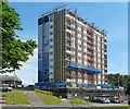
Renovation of Hillview, Gaer, Newport
This tower block was built in 1975 and is undergoing extensive external and internal renovation.
Externally there will be a new roof and cladding to improve the building's insulation.
The flats are undergoing major redesign and will have double glazed windows, new electric heating systems and gel core electric panel radiators.
The cost of the work on this block and two others in Newport will be about £10 million.
For a closer view of the renovation work see http://www.geograph.org.uk/photo/4071615 .
For a view before refurbishment see http://www.geograph.org.uk/photo/1515795 .
Image: © Robin Drayton
Taken: 11 Jul 2014
0.00 miles
3
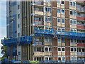
Renovation in progress, Gaer, Newport
External platform lifts have been constructed on each side of the building.
For a wider view and details of the renovation see http://www.geograph.org.uk/photo/4071605 .
Image: © Robin Drayton
Taken: 11 Jul 2014
0.00 miles
4
Block of flats undergoing recladding, Gaer Rd, Newport
Image: © John Lord
Taken: 22 Nov 2014
0.00 miles
5
Side road to a church, Gaer, Newport
Ascending from Gaer Road to St Martin in the Gaer church. https://www.geograph.org.uk/photo/5862250
Image: © Jaggery
Taken: 6 May 2016
0.01 miles
6
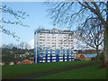
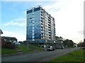
Hillview Flats, Gaer, Newport
Built in 1975, this prominent block of flats on the Gaer Estate has been re-clad twice in the past five years. See https://www.geograph.org.uk/photo/5997808 for an earlier picture.
More communication equipment for the 5G upgrade has recently been added to the roof.
Image: © Robin Drayton
Taken: 12 Mar 2020
0.01 miles
7
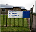
Information board outside St Martin in the Gaer church, Newport
Near the church entrance. https://www.geograph.org.uk/photo/5862250 In May 2016 Eucharist is at 9:30am on Sundays.
Image: © Jaggery
Taken: 6 May 2016
0.01 miles
8
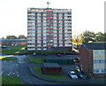
Hillview multi-storey block viewed from Shakespeare Crescent, Newport
The block in Gaer Road, built in 1975, is 37 metres (c120 ft) high. It contains 111 flats.
Image: © Jaggery
Taken: 6 Oct 2012
0.01 miles
9
Hillview now renovated, Gaer, Newport
See http://www.geograph.org.uk/photo/4071605 for the renovation underway.
Image: © Robin Drayton
Taken: 16 May 2015
0.01 miles
10
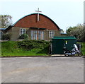
Gaer Tower electricity substation, Newport
Located between St Martin in the Gaer church and a Yamaha motorbike, the dark green cabinet is a Western Power Distribution electricity substation. Its identifier is GAER TOWER S/S 53-7187.
Image: © Jaggery
Taken: 6 May 2016
0.01 miles