IMAGES TAKEN NEAR TO
Shakespeare Crescent, NEWPORT, NP20 3HW
Introduction
This page details the photographs taken nearby to Shakespeare Crescent, NP20 3HW by members of the Geograph project.
The Geograph project started in 2005 with the aim of publishing, organising and preserving representative images for every square kilometre of Great Britain, Ireland and the Isle of Man.

There are currently over 7.5m images from over14,400 individuals and you can help contribute to the project by visiting https://www.geograph.org.uk
Image Map
Images are licensed for reuse under creativecommons.org/licenses/by-sa/2.0
Notes
- Clicking on the map will re-center to the selected point.
- The higher the marker number, the further away the image location is from the centre of the postcode.
Image Listing (195 Images Found)
Images are licensed for reuse under creativecommons.org/licenses/by-sa/2.0
Image
Details
Distance
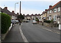
1
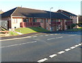
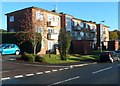
Stratford House, Newport
Located on the north side of Shakespeare Crescent, viewed from the corner of Ben Jonson Way. Stratford House, managed by Charter Housing Association, contains 17 flats, with the support
of part-time non-resident management staff and a community alarm service.
Image: © Jaggery
Taken: 6 Oct 2012
0.01 miles
2
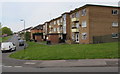
Shakespeare Crescent flats, Newport
Viewed from the corner of Gaer Road.
Image: © Jaggery
Taken: 6 May 2016
0.03 miles
3
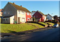
Shakespeare Crescent houses near the corner of Gaer Park Hill, Newport
Viewed from opposite the Gaer Park Hill http://www.geograph.org.uk/photo/3166072 junction.
Image: © Jaggery
Taken: 6 Oct 2012
0.03 miles
4
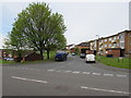
Junction of Gaer Road and Shakespeare Crescent, Newport
Across Gaer Road towards the NE end of Shakespeare Crescent which extends for 1.3km to Masefield Vale.
Image: © Jaggery
Taken: 6 May 2016
0.04 miles
5
South along Gaer Park Drive, Newport
Towards the Gaer Park Hill junction.
Image: © Jaggery
Taken: 6 May 2016
0.04 miles
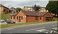
6
Gaer Medical Centre, Newport
Gaer Road side of the building on the corner of Shakespeare Crescent.
Gaer Clinic http://www.geograph.org.uk/photo/4948969 is nearby.
Image: © Jaggery
Taken: 6 May 2016
0.04 miles
7
Gaer Medical Centre, Newport
On Gaer Road, near the junction with Shakespeare Crescent.
Image: © Jaggery
Taken: 1 Oct 2009
0.05 miles
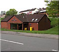
8
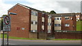
Fort Lee housing project, Gaer, Newport
On Gaer Road, opposite Hillview multi-storey flats. A development housing scheme completed in October 1975 by Newport Borough Council. A plaque and a sign on the building both refer to Fort Lee, but most Google references to the building spell it Fort Lea.
Image: © Jaggery
Taken: 1 Oct 2009
0.05 miles
9
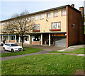
Bonsai, Gaer, Newport
Chinese takeaway at 61 Gaer Road, at the northern end of a long row of shops.
Image: © Jaggery
Taken: 6 May 2016
0.05 miles
10
Flats at the NE end of Shakespeare Crescent, Newport
The flats are near the Gaer Road junction, ahead.
Image: © Jaggery
Taken: 6 Oct 2012
0.05 miles