IMAGES TAKEN NEAR TO
Gaer Vale, NEWPORT, NP20 3HT
Introduction
This page details the photographs taken nearby to Gaer Vale, NP20 3HT by members of the Geograph project.
The Geograph project started in 2005 with the aim of publishing, organising and preserving representative images for every square kilometre of Great Britain, Ireland and the Isle of Man.

There are currently over 7.5m images from over14,400 individuals and you can help contribute to the project by visiting https://www.geograph.org.uk
Image Map
Images are licensed for reuse under creativecommons.org/licenses/by-sa/2.0
Notes
- Clicking on the map will re-center to the selected point.
- The higher the marker number, the further away the image location is from the centre of the postcode.
Image Listing (249 Images Found)
Images are licensed for reuse under creativecommons.org/licenses/by-sa/2.0
Image
Details
Distance
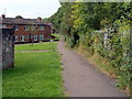
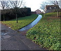
1
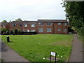
Gaer Vale housing, Newport
Ahead are a few of the 154 houses and flats in Gaer Vale. Viewed from a footpath junction on the NW edge of the estate.
Image: © Jaggery
Taken: 23 Aug 2011
0.01 miles
2
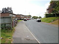
Shakespeare Crescent, Gaer, Newport
Heading away from Masefield Vale and Gaer Baptist church towards the Morton Way junction.
Image: © Jaggery
Taken: 1 Oct 2009
0.06 miles
3
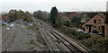
The view east from Park Junction, Gaer, Newport
The tracks head away from Park Junction towards the main line at Ebbw Junction.
7-foot (about 2 metres) high solid walls on both sides of the Park Junction footbridge are not photographer-friendly, so this view doesn't show the track, beyond the left edge of the photo, which heads towards Gaer Tunnel.
Image: © Jaggery
Taken: 12 Nov 2009
0.06 miles
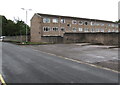
4
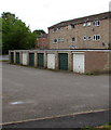
Eight lockup garages, Gaer Vale, Newport
Built in c2000, Gaer Vale is an area of housing at the SE edge of the Gaer Estate.
Image: © Jaggery
Taken: 15 Aug 2018
0.06 miles
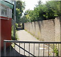
5
Footpath through Gaer Vale, Newport
The footpath, on the northern edge of Gaer Vale, runs alongside a railway fence from Gaer Road (behind the camera) to a wall http://www.geograph.org.uk/photo/2566844 at the western edge of Gaer Vale.
Image: © Jaggery
Taken: 23 Aug 2011
0.06 miles
6
Path to Gaer Vale, Newport
A footpath heads away from Cardiff Road towards steps leading up to Gaer Vale.
On the left is the edge of Cardiff Road post office. http://www.geograph.org.uk/photo/982764
Image: © Jaggery
Taken: 20 Jun 2010
0.07 miles
7
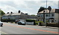
Cardiff Road houses, Newport
Houses on the Gaer side of the road, between Gaer Road and the railway bridge.http://www.geograph.org.uk/photo/1925678
Image: © Jaggery
Taken: 20 Jun 2010
0.07 miles
9
Path from Cardiff Road to St Davids Crescent, Maesglas, Newport
Image: © Jaggery
Taken: 25 Dec 2013
0.08 miles
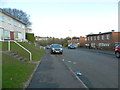
10
Three-storey flats, Gaer Vale, Newport
Built in c2000, Gaer Vale is an area of housing at the SE edge of the Gaer Estate.
Image: © Jaggery
Taken: 15 Aug 2018
0.08 miles