1
Gaer Estate and view over Newport (1)
The Gaer estate was one of the first estates built in Newport after the Second World War.
All of the streets are named after writers.
A Festival of Britain award was received for the design of the estate http://www.geograph.org.uk/photo/621755 .
Built in a hilly area in the west of Newport, it gives extensive views over Newport Docks and the Severn Estuary.
The City Bridge http://www.geograph.org.uk/photo/1140452 can be seen on the horizon to the left of centre, while the Transporter Bridge http://www.geograph.org.uk/photo/666383 can just be seen above the trees on the right.
See http://www.geograph.org.uk/photo/5530023 for the view to the right of this one.
Image: © Robin Drayton
Taken: 5 Sep 2017
0.03 miles
2
South side of Byron Road, Newport
Houses on the south side of Byron Road, between the west http://www.geograph.org.uk/photo/2171880 and east http://www.geograph.org.uk/photo/2171894 ends of Rupert Brooke Drive.
Image: © Jaggery
Taken: 22 Nov 2010
0.04 miles
3
Eastern end of Rupert Brooke Drive, Newport
Viewed across Byron Road.
Image: © Jaggery
Taken: 22 Nov 2010
0.04 miles
4
Distinctive house, New Pastures, Newport
A house with an Alpine style steeply-sloping roof is distinctly different from the other houses in New Pastures. http://www.geograph.org.uk/photo/2173737
Image: © Jaggery
Taken: 22 Nov 2010
0.04 miles
5
New Pastures, Newport
Houses on the north side of New Pastures, a cul-de-sac connecting with Cae Perllan Road.
Image: © Jaggery
Taken: 22 Nov 2010
0.05 miles
6
Gaer Estate and view over Newport (2)
The Gaer estate was one of the first estates built in Newport after the Second World War.
All of the streets are named after writers.
A Festival of Britain award was received for the design of the estate http://www.geograph.org.uk/photo/621755 .
Built in a hilly area in the west of Newport, it gives extensive views over Newport Docks and the Severn Estuary.
The Uskmouth power station complex is to the right of centre.
See http://www.geograph.org.uk/photo/5530008 for the view to the left of this one.
Image: © Robin Drayton
Taken: 5 Sep 2017
0.05 miles
7
Cae Brynton Road
Image: © Robin Drayton
Taken: 22 Jan 2009
0.06 miles
8
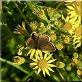
Brown Argus butterfly on Ragwort
This is the same butterfly as shown here https://www.geograph.org.uk/photo/7548288 .
Image: © Robin Drayton
Taken: 21 Jul 2023
0.07 miles
9
Parhelion (sundog)
After seeing the astronomical phenomenon of a supermoon total lunar eclipse during the early hours of the day, this atmospheric optical phenomenon appeared just before sunset.
Sundogs appear level with the sun and, depending upon the cloud cover, one or two may be visible. The redish side of the sundog appears nearest to the sun, so in this picture the sun is off to the left.
(With acknowledgement to The Cloud Collector's Handbook by Gavin Pretor-Pinney)
Image: © Robin Drayton
Taken: 28 Sep 2015
0.08 miles
10
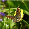
Brown Argus butterfly on a Buttercup
This is the same butterfly as shown here https://www.geograph.org.uk/photo/7548288 .
Image: © Robin Drayton
Taken: 21 Jul 2023
0.09 miles


