IMAGES TAKEN NEAR TO
Byron Road, NEWPORT, NP20 3HJ
Introduction
This page details the photographs taken nearby to Byron Road, NP20 3HJ by members of the Geograph project.
The Geograph project started in 2005 with the aim of publishing, organising and preserving representative images for every square kilometre of Great Britain, Ireland and the Isle of Man.

There are currently over 7.5m images from over14,400 individuals and you can help contribute to the project by visiting https://www.geograph.org.uk
Image Map
Images are licensed for reuse under creativecommons.org/licenses/by-sa/2.0
Notes
- Clicking on the map will re-center to the selected point.
- The higher the marker number, the further away the image location is from the centre of the postcode.
Image Listing (152 Images Found)
Images are licensed for reuse under creativecommons.org/licenses/by-sa/2.0
Image
Details
Distance
1
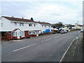
North side of Melfort Road, Newport
Steel-framed houses viewed from near the corner of Byron Road.
Image: © Jaggery
Taken: 22 Nov 2010
0.01 miles
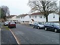
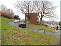
2
Byron Road, Newport
The view south from Stelvio Park Drive, looking past trees at the intersection with Melfort Road, towards houses on Rupert Brooke Drive and Browning Close.
Image: © Jaggery
Taken: 22 Nov 2010
0.05 miles
3
Tree-lined corner of Melfort Road and Byron Road, Newport
Viewed across Byron Road.
Image: © Jaggery
Taken: 22 Nov 2010
0.05 miles
4
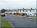
South side of Byron Road, Newport
Houses on the south side of Byron Road, between the west http://www.geograph.org.uk/photo/2171880 and east http://www.geograph.org.uk/photo/2171894 ends of Rupert Brooke Drive.
Image: © Jaggery
Taken: 22 Nov 2010
0.06 miles
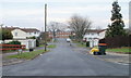
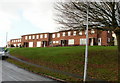
5
Steel-framed houses, Stelvio Park Drive, Newport
Most of the houses on Stelvio Park Drive are brick built. These, on the south side of the road east of Byron Road, are smaller, steel-framed houses.
Image: © Jaggery
Taken: 22 Nov 2010
0.06 miles
6
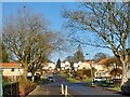
Byron Road, Gaer, Newport
At the crossing with Melfort Road.
Image: © Robin Drayton
Taken: 25 Jan 2017
0.07 miles
7
Byron Road, Gaer, Newport
Housing on the north side of Byron Road, close to the Cae Perllan Road junction.
Image: © Jaggery
Taken: 3 Dec 2009
0.08 miles
8
Path from Byron Road to Melfort Road, Newport
30 metres west of the turning for Anderson Close, http://www.geograph.org.uk/photo/2172749 a path climbs away from Byron Road towards Melfort Road houses.
Image: © Jaggery
Taken: 22 Nov 2010
0.08 miles
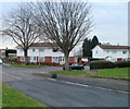
9
Anderson Close, Newport
Anderson Close curves away from Byron Road. There are some lock-up garages, but no houses, on Anderson Close. Steps gives access from the garages to the back of the block of flats seen here, on Byron Road.
At the right edge of the photo is a turquoise-coloured recycling lorry, collecting various items such as paper, glass, plastics and old clothes. These lorries are a common sight in Newport. They visit each street once a week, Mondays to Fridays, on the same day for any particular street each week.
Image: © Jaggery
Taken: 22 Nov 2010
0.08 miles
10

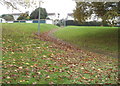
Sunset, Gaer Estate, Newport
This was my last walk in 2020 under tier 4 lockdown rules for Wales.
We are allowed out of our homes to exercise, for unlimited times and periods each day. This is less stringent than the first lockdown in April 2020 when even the local parks were closed https://www.geograph.org.uk/photo/6447822 .
Image: © Robin Drayton
Taken: 31 Dec 2020
0.08 miles