IMAGES TAKEN NEAR TO
Highfield Road, NEWPORT, NP20 3GW
Introduction
This page details the photographs taken nearby to Highfield Road, NP20 3GW by members of the Geograph project.
The Geograph project started in 2005 with the aim of publishing, organising and preserving representative images for every square kilometre of Great Britain, Ireland and the Isle of Man.

There are currently over 7.5m images from over14,400 individuals and you can help contribute to the project by visiting https://www.geograph.org.uk
Image Map
Images are licensed for reuse under creativecommons.org/licenses/by-sa/2.0
Notes
- Clicking on the map will re-center to the selected point.
- The higher the marker number, the further away the image location is from the centre of the postcode.
Image Listing (216 Images Found)
Images are licensed for reuse under creativecommons.org/licenses/by-sa/2.0
Image
Details
Distance
1
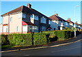
Highfield Road, Newport
Houses on the south side of Highfield Road, viewed from the Gaer Road end near the Burnfort Road junction.
Image: © Jaggery
Taken: 6 Oct 2012
0.02 miles
2
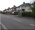
Highfield Road bus shelter, Newport
On the side of the road for buses towards the city centre.
Image: © Jaggery
Taken: 6 May 2016
0.02 miles
3
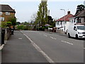
West along Highfield Road, Newport
Towards the Gaer Park Drive junction.
Image: © Jaggery
Taken: 6 May 2016
0.02 miles
4
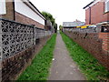
Path to Burnfort Road, Newport
From the south side of Bassaleg Road.
Image: © Jaggery
Taken: 17 Mar 2017
0.02 miles
5
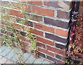
Ordnance Survey Cut Mark
This OS cut mark can be found on No10 Highfield Road. It marks a point 65.432m above mean sea level.
Image: © Adrian Dust
Taken: 2 Aug 2021
0.02 miles
6
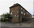
Watch the rugby here, Newport
The banner is on the north (Highfield Road) side of Gaer Park Club and Institute.http://www.geograph.org.uk/photo/2153411
Image: © Jaggery
Taken: 6 May 2016
0.03 miles
7
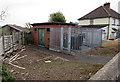
Gaer Park Drive electricity substation, Newport
The Western Power Distribution electricity substation is set back from the east side of Gaer Park Drive.
Image: © Jaggery
Taken: 6 May 2016
0.03 miles
8
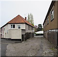
Lane from Gaer Park Drive to Highfield Road, Newport
Gaer Park Club and Institute http://www.geograph.org.uk/photo/2153411 is on the right.
Image: © Jaggery
Taken: 6 May 2016
0.03 miles
9
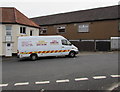
G.W.D. Homecare van, Gaer Park Drive, Newport
Parked near the Beresford Centre. http://www.geograph.org.uk/photo/4943094 G.W.D. Homecare is based in Granville Lane, Newport.
Image: © Jaggery
Taken: 6 May 2016
0.03 miles
10
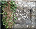
Ordnance Survey Cut Mark
This OS cut mark can be found on the west angle of the Gaer Park Club. It marks a point 69.614m above mean sea level.
Image: © Adrian Dust
Taken: 2 Aug 2021
0.03 miles