IMAGES TAKEN NEAR TO
Drinkwater Rise, NEWPORT, NP20 3GR
Introduction
This page details the photographs taken nearby to Drinkwater Rise, NP20 3GR by members of the Geograph project.
The Geograph project started in 2005 with the aim of publishing, organising and preserving representative images for every square kilometre of Great Britain, Ireland and the Isle of Man.

There are currently over 7.5m images from over14,400 individuals and you can help contribute to the project by visiting https://www.geograph.org.uk
Image Map
Images are licensed for reuse under creativecommons.org/licenses/by-sa/2.0
Notes
- Clicking on the map will re-center to the selected point.
- The higher the marker number, the further away the image location is from the centre of the postcode.
Image Listing (156 Images Found)
Images are licensed for reuse under creativecommons.org/licenses/by-sa/2.0
Image
Details
Distance
1
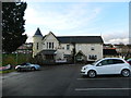
![The Gaer Inn [2]](https://s1.geograph.org.uk/geophotos/01/13/60/1136017_9d742912_120x120.jpg)
The Gaer Inn [2]
For a closer view see http://www.geograph.org.uk/photo/537653 .
The Gaer Junior School is behind the inn.
Image: © Robin Drayton
Taken: 23 Dec 2008
0.02 miles
2
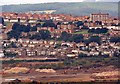
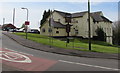
View towards the Gaer Estate (2)
Taken in 1996 from Newport Transporter Bridge.
Image: © Robin Drayton
Taken: Unknown
0.03 miles
3
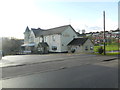
![The Gaer Inn [1]](https://s1.geograph.org.uk/photos/53/76/537653_6ee88462_120x120.jpg)
The Gaer Inn [1]
The Gaer is an area of Newport. The meaning of caer/gaer is fort or stronghold.
This was formerly Gaer Fach farmhouse.
Image: © Robin Drayton
Taken: 11 Aug 2007
0.03 miles
6
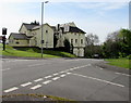
West side of the Gaer pub, Newport
The Masefield Vale side of the pub on the corner of Gaer Road.
Image: © Jaggery
Taken: 6 May 2016
0.04 miles
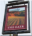
7
The Gaer, Newport
Pub on the corner of Gaer Road and Masefield Vale.
http://www.geograph.org.uk/photo/4948953 to a closer view of the name sign.
Image: © Jaggery
Taken: 6 May 2016
0.05 miles
8
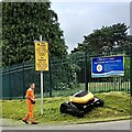
Cutting the verge, Gaer, Newport
‘No mow May’ has now passed.
This remote controlled mower is being used to cut the long grass on a steep verge.
I was told that it can do the job of four persons.
Image: © Robin Drayton
Taken: 17 Jun 2021
0.05 miles
9
The Gaer name sign, Newport
Located here. http://www.geograph.org.uk/photo/4948943
Image: © Jaggery
Taken: 6 May 2016
0.06 miles
10
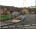
Drinkwater Close, Gaer, Newport
Bungalows on the south side of the Close, viewed from Drinkwater Gardens.
For over 50 years, until the early years of the 21st century, there were dozens of prefabs (prefabricated bungalows) in this part of the Gaer Estate. They were erected to meet the severe housing shortage in Newport after the Second World War. Modern bungalows, such as those seen here, replaced the prefabs.
Image: © Jaggery
Taken: 3 Dec 2009
0.06 miles