1
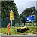
Cutting the verge, Gaer, Newport
‘No mow May’ has now passed.
This remote controlled mower is being used to cut the long grass on a steep verge.
I was told that it can do the job of four persons.
Image: © Robin Drayton
Taken: 17 Jun 2021
0.04 miles
2
Retaining wall, Drinkwater Gardens, Gaer, Newport
On the east side of the steeply-inclined Drinkwater Gardens, http://www.geograph.org.uk/photo/1606201 a retaining wall encloses the garden of the adjoining house.
Image: © Jaggery
Taken: 3 Dec 2009
0.05 miles
3
Lansdowne Road, Newport
Houses on the east side of Lansdowne Road, viewed from Gaer Road.
Image: © Jaggery
Taken: 3 Dec 2009
0.05 miles
4
View towards the Gaer Estate (2)
Taken in 1996 from Newport Transporter Bridge.
Image: © Robin Drayton
Taken: Unknown
0.05 miles
5
Gaer Junior School, Newport
Image: © John Lord
Taken: 22 Nov 2014
0.06 miles
6
The Gaer Inn [2]
For a closer view see http://www.geograph.org.uk/photo/537653 .
The Gaer Junior School is behind the inn.
Image: © Robin Drayton
Taken: 23 Dec 2008
0.06 miles
7
The Gaer Inn [1]
The Gaer is an area of Newport. The meaning of caer/gaer is fort or stronghold.
This was formerly Gaer Fach farmhouse.
Image: © Robin Drayton
Taken: 11 Aug 2007
0.07 miles
8
The Gaer Inn, Newport
Image: © John Lord
Taken: 22 Nov 2014
0.07 miles
9
Drinkwater Close, Gaer, Newport
Bungalows on the south side of the Close, viewed from Drinkwater Gardens.
For over 50 years, until the early years of the 21st century, there were dozens of prefabs (prefabricated bungalows) in this part of the Gaer Estate. They were erected to meet the severe housing shortage in Newport after the Second World War. Modern bungalows, such as those seen here, replaced the prefabs.
Image: © Jaggery
Taken: 3 Dec 2009
0.08 miles
10
Drinkwater Rise, Gaer, Newport
Bungalows on Drinkwater Rise, viewed from Drinkwater Gardens.
For over 50 years, until the early years of the 21st century, there were dozens of prefabs (prefabricated bungalows) in this part of the Gaer Estate. They were erected to meet the severe housing shortage in Newport after the Second World War. Modern bungalows, such as those seen here, replaced the prefabs.
Image: © Jaggery
Taken: 3 Dec 2009
0.08 miles


![The Gaer Inn [2]](https://s1.geograph.org.uk/geophotos/01/13/60/1136017_9d742912_120x120.jpg)
![The Gaer Inn [1]](https://s1.geograph.org.uk/photos/53/76/537653_6ee88462_120x120.jpg)


