IMAGES TAKEN NEAR TO
Cae Perllan Road, NEWPORT, NP20 3FW
Introduction
This page details the photographs taken nearby to Cae Perllan Road, NP20 3FW by members of the Geograph project.
The Geograph project started in 2005 with the aim of publishing, organising and preserving representative images for every square kilometre of Great Britain, Ireland and the Isle of Man.

There are currently over 7.5m images from over14,400 individuals and you can help contribute to the project by visiting https://www.geograph.org.uk
Image Map
Images are licensed for reuse under creativecommons.org/licenses/by-sa/2.0
Notes
- Clicking on the map will re-center to the selected point.
- The higher the marker number, the further away the image location is from the centre of the postcode.
Image Listing (252 Images Found)
Images are licensed for reuse under creativecommons.org/licenses/by-sa/2.0
Image
Details
Distance
1
Caer Perllan Road
See http://www.geograph.org.uk/photo/745703 for the view from the top right of this picture.
Image: © Robin Drayton
Taken: 27 Mar 2008
0.00 miles
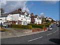
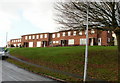
2
Newport : Cae Perllan Road houses viewed from Byron Road
The view illustrates the steep slope along much of the length of Cae Perllan Road.
The semi on the right side of each building is set about a metre lower than its neighbour on the left side.
Image: © Jaggery
Taken: 22 Nov 2010
0.02 miles
3
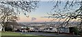
View over Newport from the Gaer
With the Severn Estuary and the North Somerset coast in the far distance.
On a cold and still evening, there is a man-made cumulus or 'fumulus' cloud, the source of which I have been unable to ascertain, and some remnants of stratocumulus clouds to the right.
This was my last walk in 2020 under tier 4 lockdown rules for Wales.
We are allowed out of our homes to exercise, for unlimited times and periods each day. This is less stringent than the first lockdown in April 2020 when even the local parks were closed https://www.geograph.org.uk/photo/6447822 .
Image: © Robin Drayton
Taken: 31 Dec 2020
0.04 miles
4
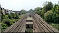
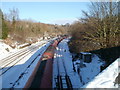
Gaer Junction, Newport
The view to the SW from a footbridge. The single track in the distance on the right heads towards Gaer Tunnel and then Park Junction. http://www.geograph.org.uk/photo/1579956 All the other tracks are part of the South Wales main line.
A few tens of metres behind the camera are the two portals of Hillfield Tunnel, http://www.geograph.org.uk/photo/1441421 leading to Newport railway station.
Image: © Jaggery
Taken: 29 Apr 2011
0.04 miles
5
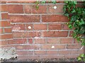
Ordnance Survey Cut Mark
This OS cut mark can be found at the junction of Cae Perllan Road & Byron Road. It marks a point 40.441m above mean sea level.
Image: © Adrian Dust
Taken: 2 Aug 2021
0.05 miles
6
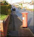
Shrunken George VI postbox, Cae Perllan Road, Newport
From a distance, I noticed something odd about this George VI postbox on the west side of Cae Perllan Road, between Byron Road and New Pastures. On close inspection, I saw that it was about a foot shorter than the usual height for a postbox. If it sinks much more, the black base will disappear and the door won't open!
Image: © Jaggery
Taken: 3 Dec 2009
0.05 miles
7
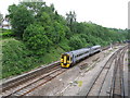
Murco train passes through Gaer Junction, Newport
A long train of 100-ton Murco wagons passes through Gaer Junction on the climb towards Hillfield tunnels. http://www.geograph.org.uk/photo/1441421
Murco Petroleum Ltd refines oil and has a network of petrol stations in the UK. http://www.geograph.org.uk/photo/1652413 Murco owns and operates four refinery terminals in the UK which receive oil by rail. They are located at Bedworth (Warwickshire), Theale (Berkshire), Westerleigh (South Gloucestershire) and Milford Haven (Pembrokeshire). The Milford Haven facility includes a marine terminal.
Image: © Jaggery
Taken: 24 Dec 2010
0.07 miles
8
South Wales Main Line, Newport
Taken from the Cardiff Road bridge.
Image: © Gareth James
Taken: 19 Jun 2010
0.08 miles
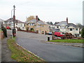
9
Byron Road, Gaer, Newport
Housing on the north side of Byron Road, close to the Cae Perllan Road junction.
Image: © Jaggery
Taken: 3 Dec 2009
0.08 miles
10
Path from Byron Road to Melfort Road, Newport
30 metres west of the turning for Anderson Close, http://www.geograph.org.uk/photo/2172749 a path climbs away from Byron Road towards Melfort Road houses.
Image: © Jaggery
Taken: 22 Nov 2010
0.08 miles