1
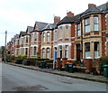
Change of house design, Ombersley Road, Newport
Houses on the north side of the road, about halfway between Bassaleg Road and Upton Road.
The houses are late Victorian, c1890.
Image: © Jaggery
Taken: 22 Nov 2010
0.01 miles
2
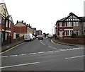
South side of Ombersley Road, Newport
Late Victorian (c1890) houses on the south side of Ombersley Road, viewed from near the corner of Upton Road.
Image: © Jaggery
Taken: 22 Nov 2010
0.01 miles
3
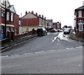
Upton Road houses, Newport
On the east side of Upton Road between Ombersley Lane on the left and Ombersley Road 45 metres ahead.
Image: © Jaggery
Taken: 19 Mar 2016
0.02 miles
4
Ford Transit van, Upton Road, Newport
The name on the van is amec foster wheeler (all lower case letters). Amec Foster Wheeler plc is a British multinational consultancy, engineering and project management company. Its headquarters are in London.
Image: © Jaggery
Taken: 19 Mar 2016
0.02 miles
5
Northeast corner of St Woolos Cemetery, Newport
A small part of a large cemetery viewed from Risca Road.
Most burials in Newport were originally in the churchyard of St Woolos cathedral, but by the middle of the 19th century this was totally inadequate for a town with a rapidly-growing population. 15 acres of land to the west of the cathedral, between Risca Road and Bassaleg Road, were obtained from the Tredegar Estate for the new St Woolos Cemetery, which opened in 1854.
It is the UK's oldest municipal cemetery. Its current dimensions are about 600 metres by 400 metres, roughly 60 acres.
Image: © Jaggery
Taken: 19 Mar 2016
0.04 miles
6
Upton Road, Newport
Upton Road ascends from the south side of Risca Road.
Image: © Jaggery
Taken: 19 Mar 2016
0.04 miles
7
Upton Road, Newport
Upton Road ascends from Risca Road towards Ombersley Lane, Ombersley Road and West Park Road.
On the left, traces of the light snowfall overnight on the 17th-18th remain on March 19th 2018.
Image: © Jaggery
Taken: 19 Mar 2018
0.04 miles
8
Row of six houses, Risca Road, Newport
The corner of Upton Road is on the left.
Image: © Jaggery
Taken: 19 Mar 2016
0.05 miles
9
Risca Road, Newport
The wall on the right is the boundary wall of St Woolos Cemetery. For an incident involving the postbox see http://www.geograph.org.uk/photo/1565697 .
Image: © Robin Drayton
Taken: 27 Oct 2009
0.05 miles
10
Blue plaque and red postbox, Risca Road, Newport
The postbox is in the wall at the northeast corner of St Woolos Cemetery.
The blue plaque http://www.geograph.org.uk/photo/4888261 records a suffragette incident involving the postbox in June 1913.
Image: © Jaggery
Taken: 19 Mar 2016
0.05 miles


