IMAGES TAKEN NEAR TO
Celynen Grove, NEWPORT, NP20 3DP
Introduction
This page details the photographs taken nearby to Celynen Grove, NP20 3DP by members of the Geograph project.
The Geograph project started in 2005 with the aim of publishing, organising and preserving representative images for every square kilometre of Great Britain, Ireland and the Isle of Man.

There are currently over 7.5m images from over14,400 individuals and you can help contribute to the project by visiting https://www.geograph.org.uk
Image Map
Images are licensed for reuse under creativecommons.org/licenses/by-sa/2.0
Notes
- Clicking on the map will re-center to the selected point.
- The higher the marker number, the further away the image location is from the centre of the postcode.
Image Listing (202 Images Found)
Images are licensed for reuse under creativecommons.org/licenses/by-sa/2.0
Image
Details
Distance
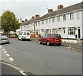
1
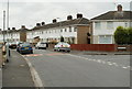
Maesglas Crescent houses near the corner of Maesglas Grove, Newport
The right turn is into Maesglas Grove.
Image: © Jaggery
Taken: 2 Aug 2011
0.01 miles
2
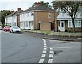
Maesglas Grove, Newport
Houses on the corner of a short western arm of Maesglas Grove. The arm http://www.geograph.org.uk/photo/2533887 on the right, leads to the entrance gates http://www.geograph.org.uk/photo/2533891 to Maesglas Grove allotments.
Image: © Jaggery
Taken: 2 Aug 2011
0.01 miles
3
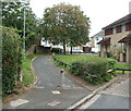
Footpath to Maesglas Grove, Newport
Viewed from the end of the roadway at the eastern end of St Brides Crescent.
Image: © Jaggery
Taken: 2 Aug 2011
0.01 miles
4
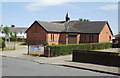
St Thomas's Church, Newport
The board at the entrance to the church from Old Cardiff Road shows
St Thomas's Church, Maesglas and Duffryn
Church in Wales
Diocese of Monmouth
The church opened in 2001, replacing a 'tin church' (made of corrugated metal) dating from 1932.
Image: © Jaggery
Taken: 20 Jun 2010
0.05 miles
5
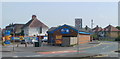
ARC car wash, Cardiff Road, Newport
Premises located on the corner of Cardiff Road (B4237) and Old Cardiff Road.
Image: © Jaggery
Taken: 26 Apr 2011
0.05 miles
6
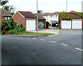
Lock-up garages, St Brides Crescent, Newport
Located between St Brides Crescent and Cardiff Road.
The opposite side http://www.geograph.org.uk/photo/2512967 on the garages on the right is overgrown with vegetation.
Image: © Jaggery
Taken: 2 Aug 2011
0.05 miles
7
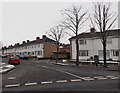
Northern end of Maesglas Grove, Newport
Viewed across Maesglas Crescent. The other end http://www.geograph.org.uk/photo/3311363 of Maesglas Grove also connects
with Maesglas Crescent, about 240 metres away.
Image: © Jaggery
Taken: 25 Jan 2013
0.05 miles
8
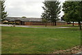
Maes Ebbw school, Maesglas, Newport
Viewed from the entrance http://www.geograph.org.uk/photo/2533841 from the north side of Maesglas Crescent. http://www.geograph.org.uk/photo/2533833
Maes Ebbw School is a day special school for pupils with severe learning difficulties. The school opened in 2001 following the amalgamation of two special schools. There are about 110 pupils enrolled, between the ages of 3 and 19. The school occupies the northern half of the site in the centre of the Maesglas district of Newport. The southern half of the site contains Maesglas Primary School.
Image: © Jaggery
Taken: 2 Aug 2011
0.06 miles
9
Western arm of Maesglas Grove, Newport
Houses on the north side of a 70 metre arm of Maesglas Grove. The arm ends at the entrance gates http://www.geograph.org.uk/photo/2533891to Maesglas Grove Allotments. Viewed from the corner of the main section of Maesglas Grove.
Image: © Jaggery
Taken: 2 Aug 2011
0.07 miles
10
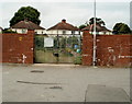
Entrance gates, Maesglas Grove Allotments, Newport
The gate is at the end of the short western arm http://www.geograph.org.uk/photo/2533887 of Maesglas Grove. The allotment site is one of 22 owned by Newport City Council. For a small annual fee, local residents can hire a plot of land for growing vegetables, fruit or flowers.
The houses in the background are part of St Brides Crescent.
Image: © Jaggery
Taken: 2 Aug 2011
0.07 miles