IMAGES TAKEN NEAR TO
Maesglas Road, NEWPORT, NP20 3DF
Introduction
This page details the photographs taken nearby to Maesglas Road, NP20 3DF by members of the Geograph project.
The Geograph project started in 2005 with the aim of publishing, organising and preserving representative images for every square kilometre of Great Britain, Ireland and the Isle of Man.

There are currently over 7.5m images from over14,400 individuals and you can help contribute to the project by visiting https://www.geograph.org.uk
Image Map
Images are licensed for reuse under creativecommons.org/licenses/by-sa/2.0
Notes
- Clicking on the map will re-center to the selected point.
- The higher the marker number, the further away the image location is from the centre of the postcode.
Image Listing (175 Images Found)
Images are licensed for reuse under creativecommons.org/licenses/by-sa/2.0
Image
Details
Distance
1
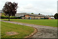
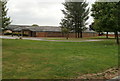
Maes Ebbw school, Newport
Viewed from the southern side.
http://www.geograph.org.uk/photo/2533870 to a view from the opposite side and a short description of the school.
Image: © Jaggery
Taken: 2 Aug 2011
0.06 miles
2
Maesglas Avenue, Newport
Viewed from the Old Cardiff Road junction
Image: © Jaggery
Taken: 16 Sep 2009
0.07 miles
3
Winchester Close, Maesglas
From Bideford Road
Image: © Jaggery
Taken: 16 Sep 2009
0.08 miles
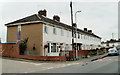
4
Northern end of Maesglas Road, Newport
Houses on the east side of the road, viewed from the corner of Old Cardiff Road.
Image: © Jaggery
Taken: 2 Aug 2011
0.09 miles
5
Corner of Maesglas Crescent and school entrance, Newport
A sign on the wall of 210 Maesglas Crescent points left towards two schools, Maes Ebbw and Maesglas Primary. Located in separate buildings, the schools share a site roughly 400 x 200 metres in the centre of the Maesglas district of Newport.
Image: © Jaggery
Taken: 2 Aug 2011
0.09 miles
6
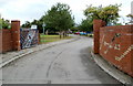
Entrance drive to two schools, Maesglas, Newport
The drive leads from Maesglas Crescent http://www.geograph.org.uk/photo/2533833 into a site roughly 400 x 200 metres. The schools, in separate buildings, are Maes Ebbw and Maesglas Primary.
Image: © Jaggery
Taken: 2 Aug 2011
0.09 miles
7
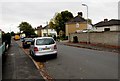
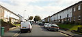
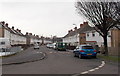
Maesglas Road, Maesglas, Newport
The walker and dog are at the Maesglas Crescent junction.
Image: © Jaggery
Taken: 11 Oct 2017
0.09 miles
8
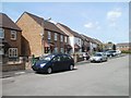
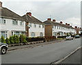
Houses at the southern edge of Bideford Road Newport
Bideford Road is the principal road through an area of houses built in the 1970s.
It is roughly 550 metres long, from Cardiff Road in the west to its southern end near the edge of the South Wales main railway line, from where this view was taken.
Image: © Jaggery
Taken: 14 Jun 2011
0.10 miles
9
Maes Ebbw school, Maesglas, Newport
Viewed from the entrance http://www.geograph.org.uk/photo/2533841 from the north side of Maesglas Crescent. http://www.geograph.org.uk/photo/2533833
Maes Ebbw School is a day special school for pupils with severe learning difficulties. The school opened in 2001 following the amalgamation of two special schools. There are about 110 pupils enrolled, between the ages of 3 and 19. The school occupies the northern half of the site in the centre of the Maesglas district of Newport. The southern half of the site contains Maesglas Primary School.
Image: © Jaggery
Taken: 2 Aug 2011
0.10 miles
10
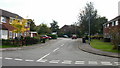
Maesglas Road, Newport
Looking WNW from Maesglas Crescent.
Image: © Jaggery
Taken: 25 Jan 2013
0.10 miles