IMAGES TAKEN NEAR TO
Bideford Road, NEWPORT, NP20 3BJ
Introduction
This page details the photographs taken nearby to Bideford Road, NP20 3BJ by members of the Geograph project.
The Geograph project started in 2005 with the aim of publishing, organising and preserving representative images for every square kilometre of Great Britain, Ireland and the Isle of Man.

There are currently over 7.5m images from over14,400 individuals and you can help contribute to the project by visiting https://www.geograph.org.uk
Image Map
Images are licensed for reuse under creativecommons.org/licenses/by-sa/2.0
Notes
- Clicking on the map will re-center to the selected point.
- The higher the marker number, the further away the image location is from the centre of the postcode.
Image Listing (173 Images Found)
Images are licensed for reuse under creativecommons.org/licenses/by-sa/2.0
Image
Details
Distance
1
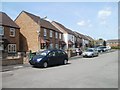
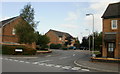
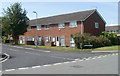
Houses at the southern edge of Bideford Road Newport
Bideford Road is the principal road through an area of houses built in the 1970s.
It is roughly 550 metres long, from Cardiff Road in the west to its southern end near the edge of the South Wales main railway line, from where this view was taken.
Image: © Jaggery
Taken: 14 Jun 2011
0.05 miles
2
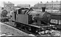
GW former Brecon & Merthyr 0-6-2T at Newport Ebbw Junction Locomotive Depot
No. 435 was built 2/21 as B&M No. 49, acquired by the GWR in 7/22 as No. 1668, renumbered 435 in 1947-50 and withdrawn in 2/54. Here in 1951 it is on an outside pit at the major Ebbw Junction Depot, which in 1950 (coded 86A) had an allocation of 143:- 12 4-6-0, 28 2-8-0 (25 GW, 3 ex-WD), 2 2-6-0 (1 GW, 1 LMS-type), 4 0-6-0, 11 2-8-2T, 29 2-8-0T, 7 2-6-2T, 7 0-6-2T, 43 0-6-0T; also 3 Diesel railcars. One of the 2-8-0s is behind.
Image: © Ben Brooksbank
Taken: 15 Apr 1951
0.06 miles
3
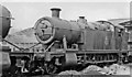
Ex-GWR 2-8-0T at Newport Ebbw Junction Locomotive Depot
One of numerous 2-8-0Ts employed on heavy coal traffic in South Wales, No. 5222 is one of the Collett '5205' class, built 5/24, withdrawn 3/65.
Image: © Ben Brooksbank
Taken: 15 Apr 1951
0.06 miles
4
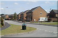
Winchester Close, Maesglas
From Bideford Road
Image: © Jaggery
Taken: 16 Sep 2009
0.06 miles
5
Bideford Close, Maesglas, Newport
From Bideford Road.
Image: © Jaggery
Taken: 16 Sep 2009
0.06 miles
6
Bideford Road houses, Newport
Bideford Road is the principal road through an area of houses built in the 1970s.
This section of the road is near its southern (railway) end. In the distance, on the right, is the Bideford Close turning. http://www.geograph.org.uk/photo/1492858
Image: © Jaggery
Taken: 14 Jun 2011
0.06 miles
7
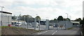
Network Rail depot, Maesglas
Network Rail Ebbw Junction infrastructure maintenance depot.
Image: © Jaggery
Taken: 16 Sep 2009
0.08 miles
8
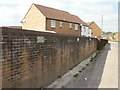
Boundary wall, Maesglas
Boundary wall between the approach road to Network Rail premises (behind camera) and houses. A sign on the wall (repeated several times along its length) warns "Do not climb on boundary wall. The top of this wall is protected by anti-climb coating which may damage clothing or footwear if this notice is ignored."
Image: © Jaggery
Taken: 16 Sep 2009
0.08 miles
9
Winchester Close houses, Newport
Houses on the west side of Winchester Close viewed across Bideford Road, the principal road through this area of housing built in the 1970s.
Image: © Jaggery
Taken: 14 Jun 2011
0.09 miles
10
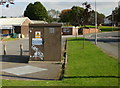
Maesglas Sewage Pumping Station
On the north side of Maesglas Avenue, close to the Sports and Social club.
Image: © Jaggery
Taken: 16 Sep 2009
0.11 miles