IMAGES TAKEN NEAR TO
Park Close, NEWPORT, NP20 3AR
Introduction
This page details the photographs taken nearby to Park Close, NP20 3AR by members of the Geograph project.
The Geograph project started in 2005 with the aim of publishing, organising and preserving representative images for every square kilometre of Great Britain, Ireland and the Isle of Man.

There are currently over 7.5m images from over14,400 individuals and you can help contribute to the project by visiting https://www.geograph.org.uk
Image Map
Images are licensed for reuse under creativecommons.org/licenses/by-sa/2.0
Notes
- Clicking on the map will re-center to the selected point.
- The higher the marker number, the further away the image location is from the centre of the postcode.
Image Listing (231 Images Found)
Images are licensed for reuse under creativecommons.org/licenses/by-sa/2.0
Image
Details
Distance
1
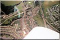
Ebbw bridge from the air.
Photo taken in 1977.
Image: © Shaun McGuire
Taken: Unknown
0.01 miles
2

Colourful house, Park Avenue, Maesglas, Newport
Image: © Jaggery
Taken: 12 Nov 2009
0.02 miles
3
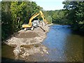
River Ebbw viewed upstream
Taken from Ebbw Bridge http://www.geograph.org.uk/photo/618007 .
Dredging spoil is being removed for disposal http://www.geograph.org.uk/photo/1483113 .
Image: © Robin Drayton
Taken: 9 Sep 2009
0.02 miles
4
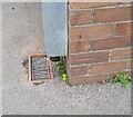
Ordnance Survey Cut Mark
This OS cut mark can be found on the west face of St David's RC School. It marks a point 17.780m above mean sea level.
Image: © Adrian Dust
Taken: 2 Aug 2021
0.03 miles
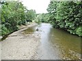
5
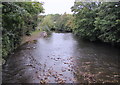
Upstream along the Ebbw River, Newport
Viewed from Ebbw Bridge which carries the B4237 Cardiff Road over the river.
The track up from the river on the left is at the edge of Tredegar Park.
The Ebbw is a major tributary of the River Usk. Their confluence is about 3km behind the camera.
Image: © Jaggery
Taken: 11 Oct 2017
0.03 miles
6
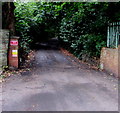
Leafy part of Park Close, Newport
Signs on the left show PRIVATE ROAD - NO PARKING
and NO FLY TIPPING - CCTV OPERATES IN THIS AREA.
Image: © Jaggery
Taken: 15 Aug 2018
0.03 miles
7
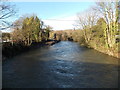
River Ebbw from Ebbw Bridge, Newport
Contrast the volume of water seen here on Christmas Day 2013 with a view taken from a similar spot in early September 2009. http://www.geograph.org.uk/photo/1483120
Image: © Jaggery
Taken: 25 Dec 2013
0.03 miles
8
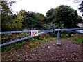
Riverside barrier, Tredegar Park, Newport
The barrier is across this http://www.geograph.org.uk/photo/5567928 track down to the Ebbw River.
Notices on the barrier show No Unauthorised Access and Danger - Vertical Drop.
Image: © Jaggery
Taken: 11 Oct 2017
0.04 miles
9
Newport, Ebbw River
Looking upstream from Ebbw Bridge.
Image: © Mike Faherty
Taken: 11 Jul 2016
0.04 miles
10
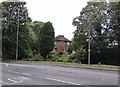
St David's Presbytery, Newport
Viewed across Cardiff Road. The presbytery (priest's or priests' house)
is located near St David's Roman Catholic Church. http://www.geograph.org.uk/photo/1580249
Image: © Jaggery
Taken: 11 Oct 2017
0.04 miles