IMAGES TAKEN NEAR TO
Gaer Road, NEWPORT, NP20 3AD
Introduction
This page details the photographs taken nearby to Gaer Road, NP20 3AD by members of the Geograph project.
The Geograph project started in 2005 with the aim of publishing, organising and preserving representative images for every square kilometre of Great Britain, Ireland and the Isle of Man.

There are currently over 7.5m images from over14,400 individuals and you can help contribute to the project by visiting https://www.geograph.org.uk
Image Map
Images are licensed for reuse under creativecommons.org/licenses/by-sa/2.0
Notes
- Clicking on the map will re-center to the selected point.
- The higher the marker number, the further away the image location is from the centre of the postcode.
Image Listing (254 Images Found)
Images are licensed for reuse under creativecommons.org/licenses/by-sa/2.0
Image
Details
Distance
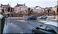
1
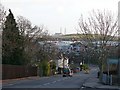
Gaer Road
The view down Gaer Road towards its junction with Cardiff Road.
For the view looking up Gaer Road see http://www.geograph.org.uk/photo/687505 .
In the centre is Image To the right of this is Image
Image: © Robin Drayton
Taken: 22 Jan 2009
0.01 miles
2
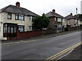
West side of Gaer Road, Newport
Semi-detached houses alongside the ascent from Cardiff Road into the Gaer Estate.
Image: © Jaggery
Taken: 15 Aug 2018
0.01 miles
3
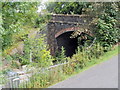
Western portal of Gaer Tunnel, Newport
Viewed from the footpath on the north side of Gaer Vale. Gaer Tunnel is 369 metres (403 yards) long. The eastern portal leads to Gaer Junction where the line joins the South Wales main line. 500 metres behind the camera is Park Junction. http://www.geograph.org.uk/photo/1579956
Image: © Jaggery
Taken: 23 Aug 2011
0.02 miles
4
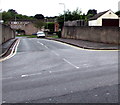
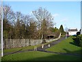
Junction of Gaer Road and Gaer Vale, Newport
Along Gaer Vale from Gaer Road near the corner of Cardiff Road.
Image: © Jaggery
Taken: 15 Aug 2018
0.03 miles
5
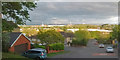
Evening view over Newport (2)
Taken from the junction of Gaer Road and the lower end of Lansdowne Road.
With Uskmouth Power Station https://www.geograph.org.uk/photo/5237263 on the horizon and the Severn Estuary beyond.
Image: © Robin Drayton
Taken: 3 May 2019
0.03 miles
6
Railway tunnel entrance, Gaer Road
This single line track is currently only used for goods traffic.
It is planned to use it for the proposed passenger service between Newport and Ebbw Vale.
(The above was written in 2009. As of 2016 this service has not materialised.)
Image: © Robin Drayton
Taken: 22 Jan 2009
0.03 miles
7
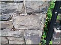
Ordnance Survey Cut Mark
This OS cut mark can be found on the SW parapet of the railway bridge. It marks a point 24.467m above mean sea level.
Image: © Adrian Dust
Taken: 2 Aug 2021
0.04 miles
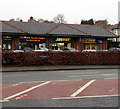
8
Betfred, Cardiff Road, Newport
Betting shop at the eastern end of Mon Bank Retail Park viewed across Gaer Road near the corner of Cardiff Road.
Image: © Jaggery
Taken: 15 Aug 2018
0.04 miles
9
Newport : Cardiff Road houses opposite Harlech Retail Park
Viewed from the access road to the retail park. The houses in this part of Cardiff Road are set several metres above road level.
Image: © Jaggery
Taken: 22 Dec 2010
0.04 miles
10
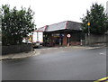
Vets4Pets, Cardiff Road, Newport
Vets4Pets Veterinary Surgery is in a row of shops on the north side of Cardiff Road, on the corner of Gaer Road. Other names in view in December 2016 are Subway and Betfred.
Image: © Jaggery
Taken: 21 Dec 2016
0.04 miles