IMAGES TAKEN NEAR TO
Cardiff Road, NEWPORT, NP20 3AA
Introduction
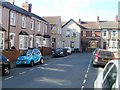
This page details the photographs taken nearby to Cardiff Road, NP20 3AA by members of the Geograph project.
The Geograph project started in 2005 with the aim of publishing, organising and preserving representative images for every square kilometre of Great Britain, Ireland and the Isle of Man.

There are currently over 7.5m images from over14,400 individuals and you can help contribute to the project by visiting https://www.geograph.org.uk
Image Map
Images are licensed for reuse under creativecommons.org/licenses/by-sa/2.0
Notes
- Clicking on the map will re-center to the selected point.
- The higher the marker number, the further away the image location is from the centre of the postcode.
Image Listing (302 Images Found)
Images are licensed for reuse under creativecommons.org/licenses/by-sa/2.0
Image
Details
Distance
1
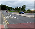
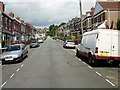
Cardiff Road bus lane, Newport
Cardiff Road descends towards Belle Vue Park and the Waterloo Road junction.
Now the B4237, this road was formerly part of the route of the A48.
Image: © Jaggery
Taken: 11 Jul 2016
0.02 miles
2
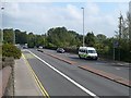
Cardiff Road
Once the A48 but now the B4237, this is looking towards Newport City centre as the road crosses the main South Wales railway.
Image: © Robin Drayton
Taken: 24 Sep 2008
0.02 miles
3
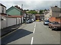
Gaer Street, Newport
Looking along Gaer Street from the junction with Waterloo Road.
Image: © Jaggery
Taken: 13 Aug 2009
0.03 miles
4
Gaer Lane, Newport
Looking up Gaer Lane from Gaer Street towards Llandaff Street.
On the left are houses in Coldra Road. On the right are houses in Waterloo Road.
Image: © Jaggery
Taken: 13 Aug 2009
0.03 miles
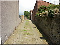
5
Coldra Road, Newport
Coldra Road rises steeply from Gaer Street towards Llandaff Street.
Image: © Jaggery
Taken: 13 Aug 2009
0.03 miles
6
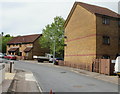
Aubrey Hames Close, Newport
Viewed from the corner of Cardiff Road.
The late Aubrey Hames was a Newport councillor, and mayor of Newport 1977-1978.
There are other examples of streets in Newport named after councillors, though
in previous generations, only the surname was used.
Image: © Jaggery
Taken: 30 May 2010
0.03 miles
7

Newport : houses between Aubrey Hames Close and Gaer Street
The houses are 1-6 Waterloo Road. The turning past the right edge of the houses is into Gaer Street.
There are no houses on the camera side of the road, only a narrow pavement alongside a perimeter wall enclosing a 2-track railway line.
Image: © Jaggery
Taken: 24 Dec 2010
0.03 miles
8
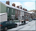
Southern side of Gaer Street, Newport
Viewed from the Waterloo Road end looking towards the right-angled turn into Coldra Road.
Image: © Jaggery
Taken: 24 Dec 2010
0.03 miles
9
Northern side of Gaer Street, Newport
Viewed from the Waterloo Road end, looking towards the right-angled bend into Coldra Road.
The turning into Gaer Lane http://www.geograph.org.uk/photo/1441364 is at the right edge of the view.
Image: © Jaggery
Taken: 24 Dec 2010
0.03 miles
10
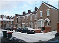
Corner houses for sale, Gaer Street and Coldra Road, Newport
Viewed along Gaer Street. The two houses for sale are at the right-angled corner. On the right is 1, Coldra Road. The house for sale on the left, 13 Gaer Street, used to contain a corner shop, decades ago.
Image: © Jaggery
Taken: 16 Oct 2011
0.03 miles