IMAGES TAKEN NEAR TO
Bolt Street, NEWPORT, NP20 2TJ
Introduction
This page details the photographs taken nearby to Bolt Street, NP20 2TJ by members of the Geograph project.
The Geograph project started in 2005 with the aim of publishing, organising and preserving representative images for every square kilometre of Great Britain, Ireland and the Isle of Man.

There are currently over 7.5m images from over14,400 individuals and you can help contribute to the project by visiting https://www.geograph.org.uk
Image Map
Images are licensed for reuse under creativecommons.org/licenses/by-sa/2.0
Notes
- Clicking on the map will re-center to the selected point.
- The higher the marker number, the further away the image location is from the centre of the postcode.
Image Listing (387 Images Found)
Images are licensed for reuse under creativecommons.org/licenses/by-sa/2.0
Image
Details
Distance
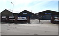
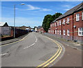
2
Bolt Street, Newport
Looking west along Bolt Street towards Commercial Road. A mixture of property usage - mainly business or industrial on the left side, mainly dwellings on the right side.
Image: © Jaggery
Taken: 27 Nov 2009
0.02 miles
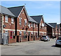
3
Houses on the north side of Bolt Street, Newport
The houses are opposite two builders merchants - Hughes Forrest https://www.geograph.org.uk/photo/5818047 and Jewson. https://www.geograph.org.uk/photo/5818096
Image: © Jaggery
Taken: 24 Jun 2018
0.03 miles
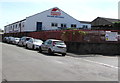
4
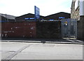
Bolt Street electricity substation, Newport
The Western Power Distribution electricity substation is on the south side of Bolt Street at the edge of a Jewson site. The substation identifier is BOLT ST. NEWPORT S/S 536347
Image: © Jaggery
Taken: 24 Jun 2018
0.04 miles
5
Bend at the eastern end of Bolt Street, Newport
Viewed from near the Canal Terrace/Enterprise Way junction looking west along Bolt Street towards Commercial Road.
Image: © Jaggery
Taken: 24 Jun 2018
0.04 miles
6

IDM Plastics, Newport
Located in Unit 1C, Enterprise Way, on the right here. https://www.geograph.org.uk/photo/5818127
Image: © Jaggery
Taken: 24 Jun 2018
0.04 miles
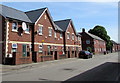
7
Modern houses, Bolt Street, Newport
On a site formerly occupied by Victorian houses demolished in the early 1990s.
Image: © Jaggery
Taken: 24 Jun 2018
0.05 miles
8

East along Bolt Street, Newport
Towards Canal Terrace and Enterprise Way.
Image: © Jaggery
Taken: 24 Jun 2018
0.05 miles
9
Hughes Forrest, Newport
Builders merchants on the south side of Bolt Street.
Image: © Jaggery
Taken: 24 Jun 2018
0.05 miles
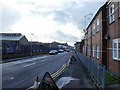
10

Duke Street, Newport
Houses on the east side of Duke Street. The view is from near the corner of Dolphin Street, looking towards Jewson http://www.geograph.org.uk/photo/2200229 on Bolt Street.
Image: © Jaggery
Taken: 17 Dec 2010
0.05 miles