IMAGES TAKEN NEAR TO
Williams Close, NEWPORT, NP20 2RS
Introduction
This page details the photographs taken nearby to Williams Close, NP20 2RS by members of the Geograph project.
The Geograph project started in 2005 with the aim of publishing, organising and preserving representative images for every square kilometre of Great Britain, Ireland and the Isle of Man.

There are currently over 7.5m images from over14,400 individuals and you can help contribute to the project by visiting https://www.geograph.org.uk
Image Map
Images are licensed for reuse under creativecommons.org/licenses/by-sa/2.0
Notes
- Clicking on the map will re-center to the selected point.
- The higher the marker number, the further away the image location is from the centre of the postcode.
Image Listing (377 Images Found)
Images are licensed for reuse under creativecommons.org/licenses/by-sa/2.0
Image
Details
Distance
1
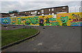
Capel Close mural, Pill, Newport
Capel Close is on the north side of Capel Crescent near the Commercial Road junction in the Pill area of Newport.
Image: © Jaggery
Taken: 29 Oct 2017
0.01 miles
2
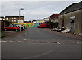
Capel Close, Pill, Newport
From Capel Crescent along Capel Close towards a mural http://www.geograph.org.uk/photo/5616600 in the Pill area of Newport.
Image: © Jaggery
Taken: 29 Oct 2017
0.02 miles
3
![A view across Newport from the Royal Gwent Hospital [2]](https://s0.geograph.org.uk/geophotos/01/31/56/1315636_5be397ef_120x120.jpg)
A view across Newport from the Royal Gwent Hospital [2]
Looking across the Pillgwenlly area of Newport towards the City Bridge http://www.geograph.org.uk/photo/1140452 .
Image: © Robin Drayton
Taken: 16 May 2009
0.03 miles
4
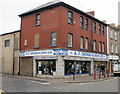
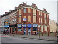
A F Thomas & Sons Ltd, Commercial Road, Newport
Electrical retailer at 145 Commercial Road. Established in 1932, this was the firm's first shop.
Its now-closed Maindee premises http://www.geograph.org.uk/photo/1452184 were acquired in 1970, and in 1992 a third shop was bought in Abergavenny. http://www.geograph.org.uk/photo/1817792
Image: © Jaggery
Taken: 5 Oct 2009
0.04 miles
5
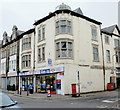
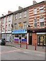
Clare Food Store, Commercial Road, Newport
On the corner of Commercial Road and Capel Crescent.
The site was formerly occupied by the Gem Cinema, which opened in 1913, closed in the 1950s, and was demolished.
Image: © Jaggery
Taken: 5 Oct 2009
0.04 miles
6
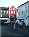
Closed pub : The Black Horse, Newport
The closed pub is located on Commercial Road, between Capel Crescent and Bolt Street.
Image: © Jaggery
Taken: 15 Dec 2010
0.04 miles
7

Albion Court, Capel Crescent, Newport
The three-storey flats are next to A & K Autokare.http://www.geograph.org.uk/photo/5616109
Image: © Jaggery
Taken: 29 Oct 2017
0.04 miles
8
Fenced-off corner of Commercial Road, Newport
A rusty metal girder frame and rough brick wall remain from whatever used to be here.
Image: © Jaggery
Taken: 20 Jul 2014
0.04 miles
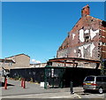
9
Former Newport Mini Market, Commercial Road
Viewed from the corner of Bolt Street. Now closed, Newport Mini Market dealt in an unusual mix of food: Polish, Lithuanian and Middle Eastern.
A relic survives a few inches above the pavement, near a red post. It is a Raglan Street sign. Raglan Street disappeared when the area now known as Francis Drive was redeveloped.
UPDATE December 2011. The building is now occupied by AZZ Designer Radiators. http://www.geograph.org.uk/photo/2721045
Image: © Jaggery
Taken: 5 Oct 2009
0.04 miles
10
Antalya, Commercial Road, Newport
There is a wide range of cuisines available from restaurants and takeaways in Commercial Road.
This one is Antalya Kebab and Pizza House, 156 Commercial Road.
Image: © Jaggery
Taken: 5 Oct 2009
0.04 miles