IMAGES TAKEN NEAR TO
Davies Square, NEWPORT, NP20 2RP
Introduction
This page details the photographs taken nearby to Davies Square, NP20 2RP by members of the Geograph project.
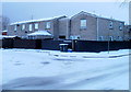
The Geograph project started in 2005 with the aim of publishing, organising and preserving representative images for every square kilometre of Great Britain, Ireland and the Isle of Man.

There are currently over 7.5m images from over14,400 individuals and you can help contribute to the project by visiting https://www.geograph.org.uk
Image Map
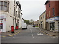
Images are licensed for reuse under creativecommons.org/licenses/by-sa/2.0
Notes
- Clicking on the map will re-center to the selected point.
- The higher the marker number, the further away the image location is from the centre of the postcode.
Image Listing (441 Images Found)
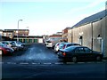
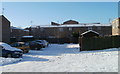
Images are licensed for reuse under creativecommons.org/licenses/by-sa/2.0
Image
Details
Distance
1
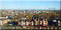
View across Pillgwenlly, Newport
Taken from the Royal Gwent Hospital https://www.geograph.org.uk/photo/5565199 .
With Cardiff Road in the foreground and on the horizon, City Bridge (to the left) https://www.geograph.org.uk/photo/3948224 and Transporter Bridge (to the right) https://www.geograph.org.uk/photo/666383 .
Image: © Robin Drayton
Taken: 24 Mar 2019
0.04 miles
2
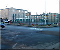
Basketball court, Francis Drive, Newport
Francis Drive is on the west side of Commercial Road. Vehicle access is from Alma Street.
Image: © Jaggery
Taken: 15 Dec 2010
0.05 miles
3
![A view across Newport from the Royal Gwent Hospital [2]](https://s0.geograph.org.uk/geophotos/01/31/56/1315636_5be397ef_120x120.jpg)
A view across Newport from the Royal Gwent Hospital [2]
Looking across the Pillgwenlly area of Newport towards the City Bridge http://www.geograph.org.uk/photo/1140452 .
Image: © Robin Drayton
Taken: 16 May 2009
0.07 miles
4
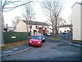
Herbert Walk, Newport
Houses in Herbert Walk are arranged around several arms radiating from the north side of Alma Street. The houses along this arm are numbered 457-482. The numbering scheme is unusual in that the sequence of numbers is shared by several streets, built at about the same time. For example, nearby Kirby Lane has about 20 properties, all numbered in the low 300s.
Image: © Jaggery
Taken: 15 Dec 2010
0.07 miles
5
Pigeons find the warm spot, Alma Street, Newport
Several dozen pigeons huddle together for warmth on a cold December day. They have chosen the only thawed section of a snowy roof. The building is a group of flats, adjacent to the car park in front of Mountjoy Christian Fellowship. http://www.geograph.org.uk/photo/2200208
Image: © Jaggery
Taken: 17 Dec 2010
0.07 miles
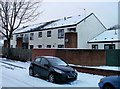
6
Charlotte Green, Newport
No, not the BBC radio news reader, but an area of flats and a few houses, on the south side of Alma Street.
Image: © Jaggery
Taken: 17 Dec 2010
0.07 miles
7
Capel Crescent, Newport
Capel Crescent heads away from Commercial Road.
On the left is Clare food store http://www.geograph.org.uk/photo/1791995 ; on the right is A F Thomas & Sons Ltd, electrical retailers. http://www.geograph.org.uk/photo/1791864
Image: © Jaggery
Taken: 5 Oct 2009
0.08 miles
8
Capel Close, Newport
Viewed across the eastern end of Capel Crescent, near the Commercial Road junction. The seven properties http://www.geograph.org.uk/photo/2207314 in Capel Close are out of shot on the left.
Image: © Jaggery
Taken: 15 Dec 2010
0.08 miles
9
Capel Close houses, Newport
Capel Close contains 7 modern houses. The close connects with the eastern end of Capel Crescent, near the Commercial Road junction.
Image: © Jaggery
Taken: 24 Dec 2010
0.08 miles
10
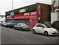
Former Kwik Save store, Newport
Located at 170 Commercial Road. The premises have been vacant since Kwik Save ceased trading in 2007. The banner on the building offers the 11,689 square feet unit for sale or to let.
Image: © Jaggery
Taken: 5 Oct 2009
0.08 miles