IMAGES TAKEN NEAR TO
Francis Close, NEWPORT, NP20 2RF
Introduction
This page details the photographs taken nearby to Francis Close, NP20 2RF by members of the Geograph project.
The Geograph project started in 2005 with the aim of publishing, organising and preserving representative images for every square kilometre of Great Britain, Ireland and the Isle of Man.

There are currently over 7.5m images from over14,400 individuals and you can help contribute to the project by visiting https://www.geograph.org.uk
Image Map
Images are licensed for reuse under creativecommons.org/licenses/by-sa/2.0
Notes
- Clicking on the map will re-center to the selected point.
- The higher the marker number, the further away the image location is from the centre of the postcode.
Image Listing (536 Images Found)
Images are licensed for reuse under creativecommons.org/licenses/by-sa/2.0
Image
Details
Distance
1
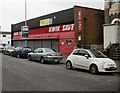
Former Kwik Save store, Newport
Located at 170 Commercial Road. The premises have been vacant since Kwik Save ceased trading in 2007. The banner on the building offers the 11,689 square feet unit for sale or to let.
Image: © Jaggery
Taken: 5 Oct 2009
0.03 miles
2
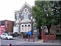
New Seasons Church, Newport
Located at 173 Commercial Road.
Kelly's Directory lists the occupiers of the building in 1901 as English Baptist Church and Bible Christian Church.
Image: © Jaggery
Taken: 5 Oct 2009
0.03 miles
3
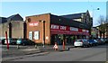
Home Furniture (UK) in former Kwik Save premises, Newport
Though the Kwik Save signs are still on the building at 170 Commercial Road, it is now occupied by Home Furniture (UK). Their banner is between two Kwik Save names on the front of the building.
Image: © Jaggery
Taken: 3 Dec 2011
0.03 miles
4
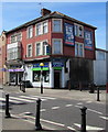
Zebra crossing to Commercial Food Stores, Newport
Lifestyle Express convenience store on the corner of Commercial Road and Francis Street.
Image: © Jaggery
Taken: 24 Jun 2018
0.03 miles
5
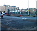
Basketball court, Francis Drive, Newport
Francis Drive is on the west side of Commercial Road. Vehicle access is from Alma Street.
Image: © Jaggery
Taken: 15 Dec 2010
0.04 miles
6
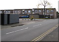
Francis Drive, Pill, Newport
Viewed across Alma Street in the Pill area of Newport.
Image: © Jaggery
Taken: 29 Oct 2017
0.04 miles
7
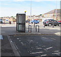
BT phonebox on a Commercial Road corner, Newport
Viewed from Dolphin Street.
Image: © Jaggery
Taken: 24 Jun 2018
0.05 miles
8
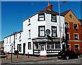
Express Pizza & Kebabs, Newport
Commercial Road takeaway viewed from the corner of Bolt Street.
Image: © Jaggery
Taken: 20 Jul 2014
0.05 miles
9
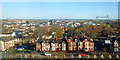
View across Pillgwenlly, Newport
Taken from the Royal Gwent Hospital https://www.geograph.org.uk/photo/5565199 .
With Cardiff Road in the foreground and on the horizon, City Bridge (to the left) https://www.geograph.org.uk/photo/3948224 and Transporter Bridge (to the right) https://www.geograph.org.uk/photo/666383 .
Image: © Robin Drayton
Taken: 24 Mar 2019
0.05 miles
10

West along Bolt Street, Newport
Towards Commercial Road.
Image: © Jaggery
Taken: 24 Jun 2018
0.05 miles