IMAGES TAKEN NEAR TO
Greenwich Road, Maesglas Industrial Estate, NEWPORT, NP20 2NN
Introduction
This page details the photographs taken nearby to Greenwich Road, Maesglas Industrial Estate, NP20 2NN by members of the Geograph project.
The Geograph project started in 2005 with the aim of publishing, organising and preserving representative images for every square kilometre of Great Britain, Ireland and the Isle of Man.

There are currently over 7.5m images from over14,400 individuals and you can help contribute to the project by visiting https://www.geograph.org.uk
Image Map
Images are licensed for reuse under creativecommons.org/licenses/by-sa/2.0
Notes
- Clicking on the map will re-center to the selected point.
- The higher the marker number, the further away the image location is from the centre of the postcode.
Image Listing (172 Images Found)
Images are licensed for reuse under creativecommons.org/licenses/by-sa/2.0
Image
Details
Distance
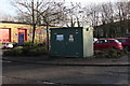
1
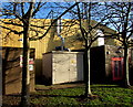
Western Power Distribution electricity substation in Maesglas Industrial Estate, Newport
The substation identifier is PLASMA TECHNICS MAESGLAS S/S No. 536344.
Image: © Jaggery
Taken: 3 Jan 2017
0.02 miles
2

Francesca and TJ Inspirations in Maesglas Industrial Estate, Newport
Viewed from Greenwich Road. TJ Inspirations laptop LCD screen supplier on the right is in Unit 19A.
Francesca Bridalwear shop in the background is in Unit 18.
Image: © Jaggery
Taken: 3 Jan 2017
0.03 miles
3

Bodycote in Maesglas Industrial Estate, Newport
Metallurgical coatings business viewed from Greenwich Road.
Image: © Jaggery
Taken: 3 Jan 2017
0.03 miles
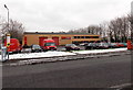
4
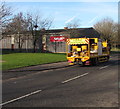
Yellow Highway Maintenance vehicle in Maesglas Industrial Estate, Newport
Viewed across Greenwich Road.
Image: © Jaggery
Taken: 3 Jan 2017
0.03 miles
5
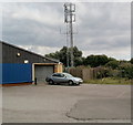
Mast, Port Road, Newport
The mast is located near the western end of Port Road, Maesglas Retail Park.
Image: © Jaggery
Taken: 28 Jul 2010
0.03 miles
6
Narduzzo in Maesglas Industrial Estate, Newport
Kitchen and tile warehouse set back from the east side of Greenwich Road.
Image: © Jaggery
Taken: 3 Jan 2017
0.05 miles
7
Greenwich Road Foul sewage pumping station, Newport
Viewed across Greenwich Road in Maesglas Industrial Estate. The identifier on the cabinet is
GREENWICH ROAD FOUL
SEWAGE PUMPING STATION.
This is Welsh Water Asset number 32920. An EX symbol on the cabinet indicates a potentially explosive atmosphere - no smoking.
Image: © Jaggery
Taken: 3 Jan 2017
0.05 miles
8
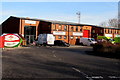
Plumbase in Maesglas Industrial Estate, Newport
Plumbers' merchants located in Unit 13, Maesglas Industrial Estate, viewed across Greenwich Road.
Image: © Jaggery
Taken: 3 Jan 2017
0.06 miles
9
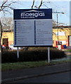
Maesglas Industrial Estate nameboard, Greenwich Road, Newport
On January 3rd 2017, the board shows 27 units (1-22 plus 12A, 13A, 16A, 19A, 20A,)
all but two of which are occupied. Some businesses occupy two units.
Located on the left here. http://www.geograph.org.uk/photo/5242855
Image: © Jaggery
Taken: 3 Jan 2017
0.06 miles
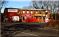
10
Parcelforce Worldwide depot, Newport
Viewed from Greenwich Road. The depot occupies Unit 21
in Maesglas Industrial Estate, on the north side of Docks Way.
Image: © Jaggery
Taken: 25 Jan 2013
0.07 miles